Mount St. Helens
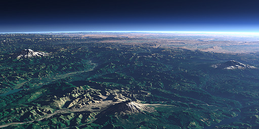
Mount St. Helens in the Cascade Range in the northwestern United States looked much like Mount Rainier (left) and Mount Adams (right) before 1980 when a large vulcanic eruption completely destroyed the mountain top. There has been occasional vulcanic activity on the mountain since then especially in the last two years.
| Ansicht: | Mount St. Helens |
| Position: | Lon -122.783° Lat 45.873° |
| Höhe: | 19 km |
| Richtung: | 53° |
| Kamerawinkel: | 42° |
| Bewertung: | 2.6 |
Umgebungskarte: Optisch Topographie

Start •
Impressum •
Nutzungsbedingungen •
Sitemap •
Bilder:
Liste
/
Karte /
Galerie •

imagico.de • blog.imagico.de • services.imagico.de • maps.imagico.de • earth.imagico.de • photolog.imagico.de
imagico.de • blog.imagico.de • services.imagico.de • maps.imagico.de • earth.imagico.de • photolog.imagico.de


Kommentare:
Durch das Abschicken Ihres Kommentars stimmen Sie der Datenschutzrichtlinie zu und erlauben, dass die eingegebenen Informationen (mit Ausnahme der eMail-Adresse) in diesem Blog veröffentlicht werden.