Views of the Earth

artificial images of our real planet
Madagascar location map

Madagascar

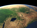
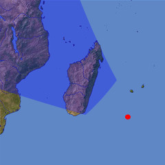
The island of Madagascar is the fourth largest island on Earth and due to its long time isolation from the African continent in the background home to many unique endemic plants and animals. Due to the trade winds the eastern coast is particularly green and humid while the central and western parts are drier.

View: Madagascar
Location: Lon 55.086°
Lat -25.938°
Altitude: 729 km
Direction: 311°
Camera Angle: 52°
User Rating: 2.4
Location Map:    Visible Topography
Madagascar location map
Madagascar

Related Views:

The Great Rift Valley

Visitor comments:

no comments yet.

Leave a comment
You have to enable Javascript to be able to write comments.
human verification Please enter the code you can see in the image on the left to verify you are a human and not a spamming script.
* * Required field
Information about you
*
will not be made public
will be displayed with your posting
Your comment (no HTML)

*

If you want to send a private message to the author of this website you can do so via Email.

The comments will be reviewed before they are added to the site. So you might need to wait some time until your entry turns up.

Please note this comment function is intended for commenting on the text and images, not for discussing political or religious views. Comments with no relation to the content of this site will not be approved.

By submitting your comment you agree to the privacy policy and agree to the information you provide (except for the email address) to be published on this website.

  
Design and Content Copyright 2023 by Christoph Hormann
last updated Sun, 16 Jul 2023 20:38