Views of the Earth

artificial images of our real planet
Lake Albert and the Albertine Rift from north location map

Lake Albert and the Albertine Rift from north

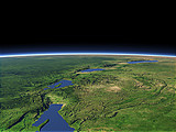
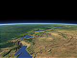
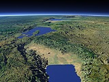
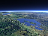
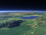
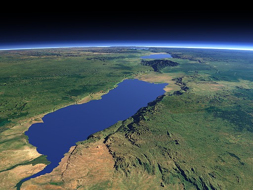
Lake Albert is the northmost of the large Rift Valley lakes in Africa with Lake Edward and Lake Kivu being visible further south in the background of this view. In the close foreground left you can see the Victoria Nile entering into the lake from the left while the outflow of the Albert Nile can be seen immediately right of it.

View: Lake Albert and the Albertine Rift from north
Location: Lon 31.502°
Lat 3.301°
Altitude: 59 km
Direction: 202°
Camera Angle: 42°
User Rating: -
Location Map:    Visible Topography
Lake Albert and the Albertine Rift from north location map
Lake Albert and the Albertine Rift from north

Related Views:

The Western Rift Valley in January
The Western Rift Valley in July
The Albertine Rift
Lake Kivu and the Virunga volcanos
The Rwenzori Mountains and Lake Edward

Visitor comments:

no comments yet.

Leave a comment
You have to enable Javascript to be able to write comments.
human verification Please enter the code you can see in the image on the left to verify you are a human and not a spamming script.
* * Required field
Information about you
*
will not be made public
will be displayed with your posting
Your comment (no HTML)

*

If you want to send a private message to the author of this website you can do so via Email.

The comments will be reviewed before they are added to the site. So you might need to wait some time until your entry turns up.

Please note this comment function is intended for commenting on the text and images, not for discussing political or religious views. Comments with no relation to the content of this site will not be approved.

By submitting your comment you agree to the privacy policy and agree to the information you provide (except for the email address) to be published on this website.

  
Design and Content Copyright 2023 by Christoph Hormann
last updated Sun, 16 Jul 2023 20:38