Views of the Earth

artificial images of our real planet
The Chesapeake Bay location map

The Chesapeake Bay

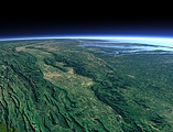
The Chesapeake Bay is a large bay at the east coast of north America formed by a large number of rivers draining into the Atlantic Ocean, the largest being the Susquehanna River (right side), the Potomac River (center) and the James River (left). On the right side at the northern end of the bay you can see the US capital Washington D.C. and Baltimore and in the background the Appalachian Mountains.
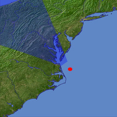
View: The Chesapeake Bay
Location: Lon -75.115°
Lat 36.435°
Altitude: 39 km
Direction: 318°
Camera Angle: 48°
User Rating: -
Location Map:    Visible Topography
The Chesapeake Bay location map
The Chesapeake Bay

Related Views:

The Shenandoah Valley

Visitor comments:

no comments yet.

Leave a comment
You have to enable Javascript to be able to write comments.
human verification Please enter the code you can see in the image on the left to verify you are a human and not a spamming script.
* * Required field
Information about you
*
will not be made public
will be displayed with your posting
Your comment (no HTML)

*

If you want to send a private message to the author of this website you can do so via Email.

The comments will be reviewed before they are added to the site. So you might need to wait some time until your entry turns up.

Please note this comment function is intended for commenting on the text and images, not for discussing political or religious views. Comments with no relation to the content of this site will not be approved.

By submitting your comment you agree to the privacy policy and agree to the information you provide (except for the email address) to be published on this website.

  
Design and Content Copyright 2023 by Christoph Hormann
last updated Sun, 16 Jul 2023 20:38