

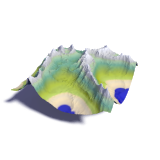
Franz Josef Land map
Franz Josef Land is a group of islands in the Russian Arctic at the northeast edge of Europe and further north than any other island in Europe and Asia. The remote location has lead to nearly all available satellite image mosaics to essentially excluding the area as can be seen for example in both Google Maps and Bing.
The map you can find here is mostly based on satellite images from the last 8 years. The relief data is older so there are significant mismatches is some parts. The satellite images layer is a mosaic created from the same Landsat images the mapping is based on. Most of the map data (except for the vegetation and relief) is available in Openstreetmap.
More details can be found in this blog post.

Visitor comments:
no comments yet.
By submitting your comment you agree to the privacy policy and agree to the information you provide (except for the email address) to be published on this website.