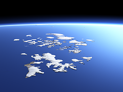
Creating 3d views of polar regions is quite difficult due to the shortage of data for these regions and the strong seasonal variability of the appearance. Franz Josef Land – which i have now newly added to both the catalog of the Imagico.de services and products and the Views of the Earth – is usually surrounded by sea ice and completely snow covered for most of the year.
A view of the whole island group is now available on the services.imagico.de catalog:
And two additional views from closer covering only parts are on the Views of the Earth:


June 26, 2014 at 22:50
Dear Chris,
Your website and work on the Franz Josef Island is amazing. Thanks a lot for that.
Would it be possible to get the 3d models you made?
I would need it for a model printout in an art project. The model would be shown in Austria, Vienna and in Budapest, Hungary in an exhibition that relates to the austro-hungarian empire.
Awaiting for your reply,
Tamás
June 27, 2014 at 09:52
Hello Tamás,
elevation data for Franz Josef Island is freely available on viewfinderpanoramas.org. I also offer satellite imagery on services.imagico.de.