First here an introductory note on my policy for reviewing geodata products – since i occasionally receive questions along the lines of why don’t you review product X by company Y. I review things i find interesting and useful or which i consider a significant innovation. In case of satellite image mosaic products i looked at the work of Mapbox and Google in depth because when these were introduced they were something new and innovative no one had done before. I did however not discuss any of the various me too products introduced since then based on Landsat or Sentinel-2 data because none of them so far shows either a significant step up in terms of quality of the results or bringing any notable technical innovation with it.
I also focus on products that are open data or are based on open data of course. This is both because this is where i am most knowledgeable in and because these i think are of most interest for my readers.
With that in mind the products of Planet Labs would not normally be subject of a review by me. While they use open data satellite imagery and offer products based on this to their customers Planet Labs does not currently offer any open data products apparently. They have a product called Open California which is supposed to be under CC-BY-SA but this is not actually publicly available (which makes it look quite strongly like openwashing).
Planet Labs is the most prominent company that has grown out of the microsatellite hype of the past years and undoubtedly the most serious player in that field for earth observation purposes. They have developed and launched a significant number of very small satellites of just a few kilograms in weight over the last years but so far the only public service available from them is a program called Planet Explorer which is a short time (one or three month) near global satellite image mosaic based on data from these and their other larger satellites (coming from a purchase back in 2015). I am reviewing this here not because of the practical usefulness of the product itself (which seems rather limited) nor because it is technically innovative (which it might be on a basic data processing level but which it certainly is not in terms of image processing). I review this here as a contribution to a fact oriented public discourse on currently produced and available satellite imagery which obviously has to include Planet Labs images.
I want to clarify that this is not a review of the Planet Labs imagery itself. Planet Explorer does not even offer a full resolution view for the unregistered user and there are currently apparently no raw sample images available for Rapideye and Plantscope imagery so a real review is not possible, at least not without signing an NDA. This only discusses the corpus of imagery as shown in Planet Explorer and which i assume to be the bulk of useful imagery currently produced by the company (in this resolution range, Planet Labs recently also purchased higher resolution satellites data from which is not included there).
Not off for a good start
To get this out of the way first – Planet Explorer uses OpenStreetMap data for their map for labels, boundaries and other stuff in clear violation of the ODbL. They mention OpenStreetMap hidden under Terms which is kind of the internet equivalent of having it placed “in the bottom of a locked filing cabinet stuck in a disused lavatory with a sign on the door saying Beware of the Leopard”. The user does not commonly get to see this which is exactly what would be required by the ODbL.
You could also call it shooting yourself in the foot with regards to public relations with the open data community. Most people can and do respect if a company business model is based on licensing data and they therefore offer none of their data as open data but tolerance ends when the very same company is too cheap to even properly acknowledge use of data they use which has been generously made available by others as open data.
I will ignore that for the purpose of this review but everyone should keep this in mind when making use of Planet Labs services of course.

What does it tell us about the data?
The map shows us aggregates of the Planet Labs imagery in either monthly or three month intervals. This comprises three different types of images at the moment apparently:
- Images from the Rapideye constellation which can be identified in the mosaic based on their relatively wide recording swath (77 km).
- Images from the very small Planetscope satellites in sun synchroneous orbit with 24 km recording width and for which Planet Labs is mostly known.
- Images from the Planetscope satellites in ISS orbit which can be distinguished from the former based on the slightly less wide swath (20 km) and the lower orbit inclination.
I won’t comment much on the assembly strategy they use – this is fairly non-sophisticated. Cloud detection and masking seems to be used for Rapideye imagery but not for the Planetscope data.
The more interesting part is coverage. Planet Labs has for a long time advertised their goal is daily coverage of the whole planet – which is of course meant for the land masses only. Their claims about to what extent they are actually doing this are always a bit fuzzy though – numbers usually appear to be theoretical goals and they speak of the ability to record a full daily coverage but do not say this is actually being recorded.
Coverage
Coverage seems to be constrained between 57°S and 76°N, the northern limit however is quite clearly not a recording limit but a processing limit. These limits by the way happen to be approximately the extent of the known world until the 17th to 18th century. Of the low latitude areas where they record they achieve approximately 90-95 percent coverage in the monthly interval at the moment (with May 2017 being the last month covered so far). It is possible that part of this is because they do not include images in processing because they are completely cloud covered and their actual coverage is slightly better. This is still pretty far away from a daily global coverage but does not preclude the possibility that their daily coverage in terms of recorded area is close to or above the total land area on earth. For the latter you just need sufficient recording capacity or in other words: enough satellites. For actual full coverage you would need to have these recordings distributed uniformly across the earth land surfaces which is a whole other problem.

Their recording strategy at the moment looks rather odd with seemingly random gaps in the recordings. I of course don’t know what technical constraints exist with these very small satellites, how specifically they can task the recordings and how far they depend on having a receiving station close-by. And keep in mind that they can’t really maneuver these satellites so they have very limited control over where the satellites look at a certain time. Imagine playing darts with a very low skill level and having the task to hit all regions of the dart board at least once. You need many more darts to accomplish this than there are regions on the board because you end up hitting many parts several time before achieving full coverage.
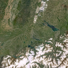
As an example here a view of their May 2017 image of southern Germany.

This has 100 percent coverage but as you can clearly see there is a strip of cloud affected images in the center part of the area indicating they don’t have any May 2017 recordings of this area without clouds (or a really bad image quality assessment as a basis of mosaic assembly – which however seems unlikely). If i look over the weather in May (based on MODIS and VIIRS imagery for example) there are at least four days with good weather in the morning to noon time frame that would have allowed for better images in the area (May 10, 17, 26 and 27). Here a quick assembly of the same area based on Sentinel-2 data from May 10 and May 27.

That i can produce this from Sentinel-2 data with a ten day recording interval is pure luck. But it shows that while the number of images recorded by Planet Labs in the area maybe could cover it completely every day based on sheer numbers the images actually recorded clearly do not by a fairly big margin. And this is at a latitude where due to the orbit geometry you already have on average a much higher potential recording density than at the equator.
Is smaller better?
From this specific analysis of the current Planet Labs offerings and capabilities i now get to the ultimate more general question – is a large number of small satellites recording a relatively narrow field of view better or worse than a small number of larger satellites with a wider field of view?
Note although the way i phrased this question is independent of the recording resolution in reality this is not the case of course – higher resolution satellites tend to have a more narrow field of view. Here a few examples:
| Satellite | mass | recording width | resolution | width in pixel (approximate) |
|---|---|---|---|---|
| Landsat | 1500 kg | 190 km | 15 m | 13000 |
| Sentinel-2 | 1100 kg | 290 km | 10 m | 30000 |
| Rapideye | 156 kg | 77 km | 6.5 m | 12000 |
| Planetscope | 6 kg | 24.6 km | 3.7 m | 6600 |
| Skysat | 83 kg | 8 km | 0.9 m | 8000 |
| Pleiades | 970 kg | 20 km | 0.7 m | 30000 |
| WorldView-4 | 2500 kg | 13.1 km | 0.31 m | 42000 |
For comparing resolutions note the Planetscope satellites are the only ones with a Bayer pattern sensor (so the specified resolution is only for all spectral bands in combination).
A very wide recording width like with Sentinel-2 causes additional problems with positional accuracy and varying illumination and viewing conditions across the field of view of course, this is not what i want to talk about here though. Without these problems there are mainly the following factors:
- Satellites recording a smaller view (in terms of viewing angle as well as for the width in pixel) can be built cheaper and more light-weight. This is the main reason for the small field of view of Planetscope.
- Smaller individual images allow more fine grained targeting of recordings – either on specific places or on good weather windows. In other words: if your recording planning is good smaller images will have a smaller average cloud coverage.
- Smaller images mean more edges between images and more problems with discontinuities in the data and assembly.
- Developing and building a larger number of smaller satellites can be significantly less expensive than building a single large satellite. Management of risks of failures during launch and operations is also easier.
- Recording in high resolution requires a certain minimum size of the optics which puts a hard constraint on the size of the satellite.
- Recording in the longer wavelength infrared (SWIR/TIR) requires cooling equipment that cannot be easily miniaturized.
As you can see there are pros and cons for both. Additional factors play in if you want to specifically target certain areas – which is what all current very high resolution systems do. I only look at things for the purpose of routine large area coverage.
If you had 16 Landsat satellites and you would properly line up their orbits for this purpose you could record a solid daily coverage (yes, you would of course need to significantly extend the ground based infrastructure for this as well). Based on just the field of view (which is a strongly simplified way to look at it) you could do the same with with just about 16*190/24.6 = 124 Planetscope satellites if you (a) can operate them on the same duty cycle (the same recording duration per orbit) – which could be realistic although current operations do not demonstrate this and (b) if you could perfectly and permanently align their orbits relative to each other – which you can’t because they lack propulsion and the options they have with controlling atmospheric drag probably do not give you sufficient control for that. Hence they would need a significantly larger number of satellites, probably several times this number – for a true daily global coverage.
My prediction is that if Planet Labs stays in business for a longer time with their current business model and the aim to provide continuous coverage of larger areas world wide on a daily basis they will probably add some form of propulsion to their satellites sooner or later.