Recently i discussed the matter of clouds in satellite images and the problem of assembling cloud free mosaics. Another angle on this subject with particular focus on the tropics has now been published by Rob Simmon of Planet Labs. While of course being geared towards advertising the company and its products (same could be said about my stuff here by the way) this pretty well catches the core of the problem, in particular the following:
Landsat collects data of Borneo every 16 days, so it would take about 5 years to be guaranteed a mostly cloudless map of the island – and even that’s not enough to compile a pristine map. Over those five years, a lot can change.
The five years is pretty ambitious by the way – you’d get something cloud reduced but not enough to appear visually clean of clouds, even if you are very good at selecting and merging the images.
You can of course also take the easy way and assemble your satellite mosaic, just declare it to be cloud free and be done with it.
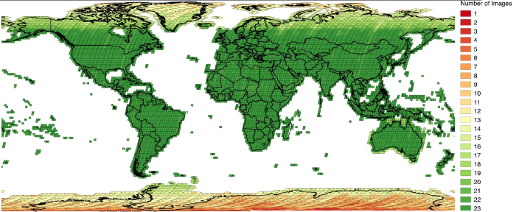
At the moment Landsat is still the only higher resolution satellite system that actually records a global unbiased coverage of the land surfaces in regular intervals – at any regular interval and both for government operated and commercial systems. The following image is from an USGS presentation showing the long term acquisition plan for Landsat 8. This differs somewhat from the actual recordings but is very close for lower latitudes now. 23 images per year corresponds to the 16 day interval – so for low latitudes almost all image recording opportunities are actually used. At high latitude the larger overlap between orbits makes this unnecessary and the polar night also eliminates some of the slots.
By the way Sentinel-2 has meanwhile significantly increased the acquisition volume and is now recording about the same area as Landsat on a daily basis – but actual acquisitions are much less uniform globally. For example in the part of Borneo Rob looked at there were only five images recorded during the last half year.
On the other hand in the three years Landsat 8 is running now there are of course also a few shots with quite reasonable coverage of the Bakun Lake – one is now in the OSM images for mapping:


