Over the winter I processed various new satellite image mosaics making use of new data from the 2016 summer and I am pleased to introduce some of these here. As usual you can find more detailed information on services.imagico.de and you can contact me in case you are interested in using one or more of these images for your own applications.
Svalbard
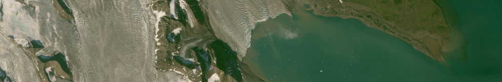
I already introduced a Svalbard image in 2015 which was and still is the highest quality image of this kind available regarding uniformity, color consistency and lack of clouds. But there always is room for improvement of course. Here is a new image of the same area based on Sentinel-2 data from 2016. The most obvious improvement is the higher resolution of course but this is not the only difference.

Sentinel-2 mosaic of Svalbard
The new image is nearly all from Sentinel-2 data from just one summer season which is somewhat astonishing considering the previous image used three years of Landsat 8 data and still required some Landsat 7 images in addition. The reason for this lies in the somewhat peculiar operation concepts of Sentinel-2. While Landsat operations try to get a nearly uniform 16 day coverage of all land areas and therefore often skips recording opportunities at high latitudes where they are not required for the 16 day interval, Sentinel-2 did not use such a rule last year in Europe leading to a very high recording frequency over Svalbard during summer. See also the coverage maps I showed some time ago. This produced a lot of fairly worthless images since there are lots of clouds in Svalbard, especially in the summer. But it also produced a higher number of images and more complete coverage during the few good weather windows in late summer last year.
This is something I have mixed feelings about. Of course it is nice for the Svalbard area but if you consider how this recording capacity could be used otherwise in areas that are currently only recorded with low priority, in particular Asia and South America, this is ultimately a fairly questionable strategy on a global level. But this is of course a political decision at ESA and there is very little chance that those making it are receptive for global and long term considerations – people do not get in such a position by putting these things first.
Also included in the Svalbard mosaic as a separate image is Bear Island which i did not have in the 2015 image because there was not enough good quality data here at that time.

Sentinel-2 mosaic of Svalbard – Bear Island
Iceland
The other large mosaic is of Iceland. Iceland is among the hardest areas on the northern hemisphere outside the tropics in terms of clouds in satellite images. When I produced 3d views of Iceland previously I heavily relied on Landsat 5 images which I did not use in this mosaic due to their age and low resolution. There is still quite a bit of room for improvements, especially regarding a tighter late summer time frame with a minimum in seasonal snow but it is the first time it was possible to produce an image of this Island within my quality standards.

Landsat Mosaic of Iceland
Jan Mayen and the Faroe Islands
And then there are two more small mosaics of the other Islands in the North Atlantic, Jan Mayen and the Faroe Islands. Jan Mayen is based mostly on Sentinel-2 data while the Faroe Islands are mostly produced from Landsat images.

Sentinel-2 mosaic of Jan Mayen

Landsat mosaic of the Faroe Islands
You can click on the images above to go to the detailed description on services.imagico.de.