I am a bit late this year but i wanted to continue with my tradition to publish a yearly analysis of the recordings of the two currently operating high resolution open data producing earth observation satellites recording in images in natural color – that is Landsat and Sentinel-2.
Superficially similar analysis is sometimes done by the satellite operators as well of course but in most cases this is not very detailed and in some cases even grossly inaccurate by considering redundancies in published data files as independent recordings (which they obviously are not). Here you can find the most accurate analysis of the spatial distribution of the recordings of Landsat and Sentinel-2 based on the actually published imagery.

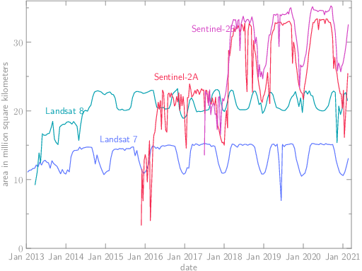
Development of total daily published image volume in square kilometers
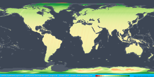
You can already see from the development of the area covered that for the most part USGS and ESA continued with the same pattern as previous years. The biggest anomaly more recently has been that the USGS apparently for unknown reason stopped off-nadir recordings of Landsat 8 in polar regions for about a year (2019 Northern hemisphere Summer and 2019/2020 southern hemisphere summer) but they have more or less resumed with the previous practice in 2020.
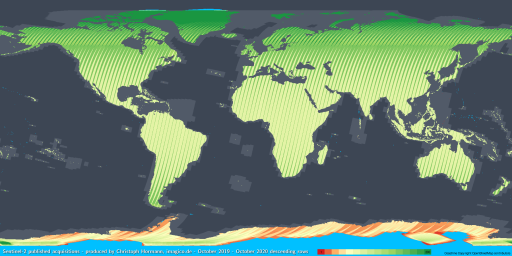
Sentinel-2 operations continued with the changes made in 2019 (that is extended high latitude coverage in the north at low sun positions with Sentinel-2B, some additional small islands) throughout 2020.
More important is what has not changed – and that is in those fields i suggested last year already – so i repeat them here:
For both USGS and ESA:
- make use of the capacity you have in the northern hemisphere winter to collect more than just sporadic data of the Antarctic.
For the USGS in addition:
- finally get rid of the last gap in your land area coverage (Iony Island).
- record off-nadir images of northern Greenland and the central Antarctic on a regular basis (and preferably make use of the flexibility you have here with the chosen path for cloud cover minimization).
And for ESA:
- stop the non-professional and short sighted catering of special interests and record images based on clear, uniform and transparent criteria.
- connected to that: rethink your strategy of recording extensive ocean areas around some islands while not recording other larger islands (South Orkney Islands) at all.
- record with Sentinel-2A and Sentinel-2B the same way or explain clearly why you don’t.
And here as in past years all of the maps showing image coverage together:
| year | day | night | day pixel coverage |
|---|---|---|---|
| 2014 | LS8, LS7 | LS8 | LS8 |
| 2015 | LS8, LS7 | LS8 | LS8 |
| 2016 | LS8, LS7 | LS8 | LS8, S2A |
| 2017 | LS8, LS7 | LS8 | LS8, S2A, S2B, S2 (both) |
| 2018 | LS8, LS7 | LS8 | LS8, S2A, S2B, S2 (both) |
| 2019 | LS8, LS7 | LS8 | LS8, S2A, S2B, S2 (both) |
| 2020 | LS8, LS7 | LS8 | LS8, S2A, S2B, S2 (both) |


