
Another recent image of the southern hemisphere winter from the highest part of the Andes mountains at the border between Chile and Argentina near Santiago de Chile. See the following map for the location.

The images used are from May/June 2014. They are mosty cloud free with some fog in the Valle Longitudinal in Chile in the southwest. Here are two magnified crops, the first from the Aconcagua, the highest mountain of the western hemisphere located on the Argentina side north of the center of this view.

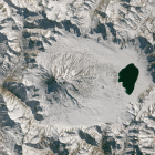
The second is of the Maipo, a volcano further to the south.

The volcanic cone of the Maipo is located within a large older volcanic Caldera with the Laguna del Diamante east of the mountain.
The Maipo approximately marks the boundary between the high Andes further to the north with peaks of 5000-6000m and higher and the lower parts further to the south. Despite the elevation the northern part receives quite little snow and therefore only features few and small glaciers. Further to the south snowfall in more extensive but mountain elevations are mosty too small for glaciers – until further to the south, outside the coverage of this image, where colder climate led to the formation of the Patagonian ice fields.
This Landsat mosaic is also available now in the catalog on services.imagico.de.