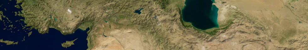
I am happy to announce the availability of the Green Marble global satellite image mosaic. Previously i showed partial coverage of Europe and the Arctic with this satellite image assembly. It took some time to complete this for the rest of the planet but processing is finished now and the full image is available.
As already explained in the previous blog posts this image shows the appearance of the earth surface at the time of the year where vegetation is at its maximum and when extent of snow and ice is lowest. This happens at different dates for different parts of the planet so the image mosaic as a whole does not show an impression you can get in reality at any given date. It does however give a typical impression for each region since what we consider as a characteristic appearance is usually not how an area looks in winter or during dry season.

When reviewing other satellite image assemblies in the past like the work of Google and Mapbox i criticized the fairly mediocre attempts in eliminating clouds from the images so it is only fair i here demonstrate that a truly cloud-free image is possible. The problem with clouds is that eliminating them kind of follows a ninety-ninety rule. Creating a mosaic that is 99 percent cloud free is fairly easy. The hard part is getting rid of the remaining ~1 percent. You can of course simply retouch the image to get rid of those residual clouds but this would be kind of cheating and the image would no more actually show the real surface color in those areas. The land areas in this mosaic are 100 percent based on actual local measurements – for the oceans this is not strictly the case, there is a significant amount of spatial blending and in-painting there. Still also the ocean coloring is not an abstract paint job but derived from satellite data.

According to my knowledge this is not only the first truly cloud free image of the planet, it is also the first one covering the whole earth surface based on actual measured data. Both the 2002 Blue Marble and the Blue Marble next generation did not cover areas north of 80 degrees latitude, the BMNG only showed the oceans in uniform color and without sea ice and the BM 2002 featured an abstract uniform color sea ice rendering. The Mapbox Cloudless Atlas similar to the BMNG does not include the oceans except for coastal areas and misses quite a number of islands.

One thing i noticed when working on this is you really get to know the various regions of the planet in a completely different way when doing this kind of processing. Normally when you visualize a certain region you at most have a handful of different images from various times of the year of the area you look at. When assembling a mosaic like this there are several hundred images for every part of the planet that need to be processed and you get a much more thorough impression of the dynamics of the area.
The Green Marble mosaic is available on services.imagico.de for licensing for custom applications. You can there also find a small size version under CC license for testing and low resolution applications.
And finally not to forget – the data source for all of this is MODIS satellite data made available by the USGS.