
Yes, i have emphasized this before but here is a great example why OpenStreetMap – in its endeavor to create the best map of the world – cannot rely on commercial services with proprietary images offered for mapping in OSM to provide images for mapping wherever they are needed.
Here an area at the northeast shore of the Caspian Sea where pretty big structures have been built recently – about 50 Kilometer long in total and most likely in connection to the nearby Kashagan oil field which you can also find in the image further to the northwest.
Neither of these (the shore structures and the oil field) you can find in any of the various global image layers available for mapping in OSM. One features a construction site at the shore in an early stage. And neither of these places is accurately mapped in OpenStreetMap.
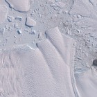
Apart from this i also added a number of other images to the OSMIM – a 2018 update for the North Sea tidalflats, an image of the recently completed bridge over the Kerch Strait – the bridge is well mapped in OSM but many of the coastal changes, access road contructions and similar related changes in the surrounding could still use updates. And finally i still have not given up on encouraging OSM mappers to work on mapping the Antarctic – with an other interesting area at the Antarctic coast being added based on recent imagery. I should probably also point out – since not everyone is probably aware of this – that nowhere on Earth is it so easy and effortless to at least locally turn OpenStreetMap into the best map of the world. If you map in this area based on the provided images (or in most of the other image areas for the Antarctic you can find in the OSMIM) you can be almost certain that what you create is the best map in the world for this particular area. And at the same time you learn quite a lot about a fairly interesting but at the same time very little known part of the world.