
Two new images were added to the OSM images for mapping layer:


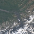
The former is from the Alaska Range which is currently quite popular since its highest mountain which is also the highest mountain in North America has recently been officially renamed to Denali. The image provides more up-to-date and largely better readable coverage of the area than the common imagery layers from Bing and Mapbox.
The latter is the Rann of Kutch i recently pointed out as the location where the coastline in OpenStreetMap contains the largest error. Although this area is well covered in Bing with high resolution images the shallow water and changing water levels make mapping based on these images very difficult. I put up a false color infrared image here from the beginning of the year, showing moderate water levels. During monsoon season much of this region is flooded and during the driest part of the year before the start of the monsoon it is even drier. Mapping based on this requires both familiarity with the area and some experience with reading false color infrared images. But based on such knowledge these images should significantly simplify proper mapping.