
This is not going to be a philosophical text on the merits of ground surveys in contrast to remote mapping, with accuracy i am referring just to the plain positional accuracy of the pixels in images, not the semantics.
A lot of people using satellite images wonder about this topic and even if you research the matter in more detail there is little hard data you can find. This is because the question can usually not be answered that easily, it is nearly always an it depends.
A bit of background – nearly all satellite images you deal with these days come from polar orbiting satellites flying at an altitude of about 700km. The pictures are taken in a size of about ten to a few hundred kilometers. If you look at this in terms of a normal camera this means a long lens but usually not excessively long. The precision at which the satellite operator knows in what direction the satellite is looking varies, it has gotten a lot better in the last decades but it is nearly never precise enough.
If the satellite is looking straight down at the earth surface, you are only concerned with the area directly at the center of the image and you know the direction your satellite is looking with a significantly better accuracy than the resolution of your sensor you are done – you have a perfectly accurate image. But that is nearly never the case.
The first and most difficult issue is that high resolution satellites with a fairly narrow field of view are nearly never looking straight down and in case of lower resolution satellites with a wider field of view you have a significant angle between the line of sight and the earth surface normal. In case of Landsat with a 190km wide field of view you are looking with an angle of more than 8 degrees at the edges, the tilt angle of high resolution satellites can be even higher. This means even when you precisely know the direction of view you still don’t know exactly where you are looking at on the earth surface if you don’t know precisely where the earth surface is. Therefore topographic data is usually required to correct the satellite images, a process called orthorectification or terrain correction.
As long as the viewing angle is still relatively small the lack of accuracy of your information on the topography will translate only into a small inaccuracy in your satellite image positioning after terrain correction is applied. But keep in mind that in steep mountain areas SRTM elevation data can for example be off by more than 100m, not to mention data gaps where you fill in even less accurate data. Therefore you will never get truly reliable accuracy information on terrain corrected satellite images.
If your area is perfectly flat this is all not an issue and your primary concern would be the precision in the view direction. To improve that the usual approach is to have a set of reference points with precisely known locations and corresponding reference images to match these to the satellite image in question. This way you can well correct for overall offsets in the image position.
For high quality processing both methods (terrain correction and reference point calibration) are combined. In case of Landsat images for example there are three different processing levels:
- Level-1G is essentially just guesswork based on knowledge of the satellite position and direction. Accuracy of such images varies a lot depending on the satellite. In case of Landsat 5 this could easily mean offsets of several hundred meters, in case of Landsat 8 these images are usually within about 50m, often better.
- Level-1Gst adds terrain correction which improves accuracy in mountain areas relative to Level-1G towards the edges of the scene. This is the standard processing for all Landsat 8 scenes where no reference point data is available or can be used (like due to cloud cover).
- Level-1T uses reference point data for additional accuracy. This is only available on a limited set of WRS2 tiles.
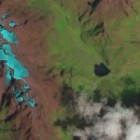
To show what this means in practice here an example from my recently introduced OSM images for mapping:

These are the Rwenzori mountains in East Africa in false color infrared. The area is partly also covered in higher resolution in Bing based on DigitalGlobe images:

There is little data in OpenStreetMap that can help to properly position these images. What we do know is that the Landsat scene in question (LC81730602015040LGN00) is Level-1T corrected (listed in the metadata as L1T), that the mountains are located just east of the center of the satellite path meaning the satellite view is nearly vertical and that there is a systematic overall offset between the Bing image and the Landsat image of about 50m (setting the offset of the Landsat image to ‘32.5;32.5’ in JOSM compensates the difference quite well with respect to the various small lakes).
After doing that in comparison we can see that on the highest mountains there is a mismatch between the Bing image and the Landsat image of about 200m. I don’t know how accurate the peak position in OSM for Margherita Peak (the highest in the mountains) is but it matches the Landsat image reasonably well while it seems to be quite a bit down the eastern slope on the Bing image:


For a Landsat scene that is corrected based on terrain data and reference points an overall offset of about 50m would be plausible although relatively large – maybe due to the reference not being very precise in this region. Since the mountains are near the satellite path center the topography has only little negative effect on accuracy. Even if the elevation data used is off by 500m this would still mean no more than a few meters offset due to topography here so it is negligible.
On the other hand this means that the Bing imagery – despite the higher resolution – is quite far off in the peak areas. It was probably taken at a significant angle. In non-urban areas where you don’t have vertical structures that can be used as indicators this is difficult to see in an image. Even if you’d align the images with precise ground survey data in the valleys you can still get huge offsets in such a case on mountains as illustrated here.
You sometimes find satellite image providers specifying much smaller errors that do not seem plausible with cases like this in mind – this is because large parts of the earth surface are relatively flat terrain and such numbers are statistical errors. If you have an error of less than 30m with 90 percent confidence globally this does not rule out that you have more that 500m error in many rugged mountain areas.
Tl;dr – High resolution images can be much less accurate than lower resolution ones, especially in mountain areas. There are no universal rules, it is important to know how images are taken and processed to assess their accuracy.