
In connection with assembly of satellite image mosaics i mentioned the effect of sun glint in satellite images in a recent post and want to elaborate a bit on this here.
Sun glint is a common phenomenon in satellite images – it essentially refers to the specular reflection of the sun on water surfaces. It is more or less the same as the sun reflection you see on a curved glass surface.
From the perspective of an earth observation satellite in sun synchronous orbit with a morning view (both Landsat and Sentinel-2 fall under this) sun glint looks like this:

This image shows a single day’s imagery of the Terra-MODIS camera from May this year. You can see the different orbits of the satellite each crossing the equator at the same local time and the small gaps between. Since the satellite photographs a morning view the sun is in the east and therefore the sun reflection is slightly to the east from the middle of the image swath. Now higher resolution satellites like Landsat and Sentinel-2 photograph a much more narrow field of view so sun glint is normally visible as a bright overlay of the water areas increasing in intensity from west to east. Here an example from Sentinel-2:


And here one from Landsat 8:

Since Sentinel-2 has a larger field of view than Landsat and a slightly later local imaging time (10:30 equator crossing time compared to 10:11) sun glint effects as well as their variability across the images are significantly stronger than with Landsat on average. The elongated form of the sun glint in flight direction is caused by the way satellites record images by scanning lines at a right angle to the direction of flight. The angle between view direction and the earth surface varies along this line but is not tilted backwards or forwards in flight direction so the glint varies strongly at a right angle to the flight path due to the view direction rotation across the field of view and changes much slower in flight direction due to just the varying orientation of the curved earth surface towards the sun.
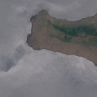
Because of the way sun glint is affected by the view geometry as described it is also strongly subject to striping in the images due to the image sensors being split into several modules in most recent earth observation satellites each of which looks either slightly forward or backward and so they are affected somewhat differently by sun glint. Here an example from Sentinel-2 showing how this typically looks.

In the first example from the Canary Islands by the way striping is not visible because this image is taken near the maximum of the sun glint and therefore the forward and backward looking sensor modules record more or less the same amount of glint.
Sun glint is generally strongest at the latitude where the sun is highest depending on the seasons. It falls off north and south of this. During mid summer the effects of sun glint can be clearly seen up to about 50 degrees latitude with Landsat, somewhat further with Sentinel-2. Correspondingly during Winter sun glint free images can be recorded at lower latitudes as well.
Since sun glint is caused by a pretty basic geometric constellation you could assume that you could compensate for it but practically this is hardly possible because of several things:
- Its strength and characteristics are highly dependent on how smooth the water surface is, i.e. waves. On the bright side this has the nice side effect that you can observe the sea state quite well on images with stong sun glint – as demonstrated by the Landsat example above.
- Water areas are generally quite dark when viewed from above especially deep and clear water so the sun glint outshines the real reflection signal and even if you could properly estimate and compensate for the amount of sun glint you would still have the actual signal buried in the noise from the specular reflection.
Generally sun glint is usually considered an undesirable effect although not really a flaw or quality deficit like clouds. Practically it is one of the main reasons why you rarely see satellite image products that include water coverage of larger water areas at lower latitudes since it is difficult to uniformly render water in areas where sun glint is present.
You might wonder how the Green Marble renders the ocean without visible sun glint. This is because the wide field of view of the MODIS instrument contains sufficient data far enough from the directions of sun glint and this data is used to determine the color in such areas. But this is not without problems either – as you probably know from looking at water surfaces from the shore reflectivity increases when you look at the surface at a flatter angle – so you might get less sun glint this way but on the other hand get a larger amount of reflected skylight.
What could help dealing with sun glint in imagery is if satellites were able to record polarization information in the light received. Specular reflection is selective regarding polarization after all. But common earth observation satellites do not do this at the moment.
Some further info and literature on sun glint can be found here.
November 13, 2020 at 00:31
Hi, I’m looking for sun glint Sentinel 2 images that cover estuaries . Could you send me the date of the one just above that shows the Mississipi mouth?
November 14, 2020 at 13:51
As you can see from the image link:
https://imagico.de/blog/wp-content/uploads/2016/09/S2A_R083_N28_20160423T163610_expose.ann_.jpg
that one is from April 2016.