Namcha Barwa and Gyala Peri
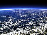
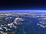
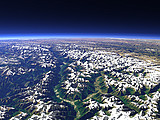
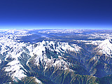
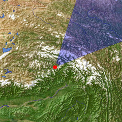
The Namcha Barwa (7782m) on the right and the Gyala Peri on the left (7294m) are a pair of mountain peaks that flank the Tsangpo Gorge where the Yarlung Tsangpo river descends from the Tibetan Plateau in a deep and narrow valley. Behind the mountains of eastern Tibet.
View: | Namcha Barwa and Gyala Peri |
Location: | Lon 94.567° Lat 29.28° |
Altitude: | 19 km |
Direction: | 40° |
Camera Angle: | 50° |
User Rating: | 2.5 |
Location Map: Visible Topography

Home •
Impressum •
Sitemap •
Browse:
list
/
map /
gallery •
imagico.de • blog.imagico.de • services.imagico.de • earth.imagico.de • photolog.imagico.de

imagico.de • blog.imagico.de • services.imagico.de • earth.imagico.de • photolog.imagico.de
Visitor comments:
Wonderful rendering of Himlayan terrain. I do not detect vertical exaggeration, which is something I avoid in my own POV-Ray landscapes, too. This reach of the Brahmaputra was once thought to contain the highest waterfalls in the world, but it proved very difficult to explore.
It is interesting that the Ganges and Brahmaputra not only arise near each other, as do the Rhine and the Danube, but that they also actually meet before entering the Bay of Bengal. One of our world's many marvels.
Thank you.
By submitting your comment you agree to the privacy policy and agree to the information you provide (except for the email address) to be published on this website.