Views of the Earth

artificial images of our real planet
The lower Danube River location map

The lower Danube River

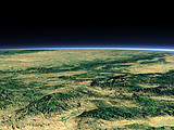
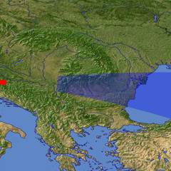
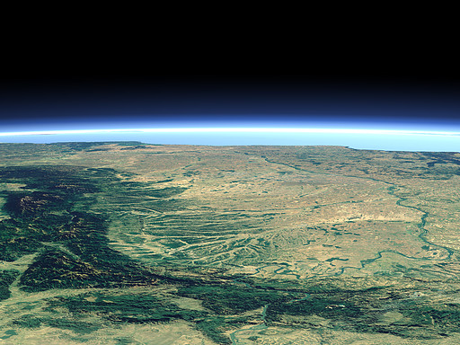
After the crossing between the Carpathian Mountains and the Balkan Mountains in the gorge called Iron Gate the Danube River flows at the border between Romania and Bulgaria, then turns north and reaches the Black Sea in the far background.

View: The lower Danube River
Location: Lon 16.358°
Lat 44.919°
Altitude: 149 km
Direction: 95°
Camera Angle: 21°
User Rating: 2.4
Location Map:    Visible Topography
The lower Danube River location map
The lower Danube River

Related Views:

The Balkan Mountains

Visitor comments:

by vio-dumi from Romania posted on Sat Jan 16 2010 02:31:50
1. only a part of Inferior Danube \\r\\n2. only a part of Meridional Carpatians\\r\\n3. better if you made 2 separately maps of this
by Lucy posted on Sat Jan 31 2009 22:54:47
does not display the location of the river well enough.
Leave a comment
You have to enable Javascript to be able to write comments.
human verification Please enter the code you can see in the image on the left to verify you are a human and not a spamming script.
* * Required field
Information about you
*
will not be made public
will be displayed with your posting
Your comment (no HTML)

*

If you want to send a private message to the author of this website you can do so via Email.

The comments will be reviewed before they are added to the site. So you might need to wait some time until your entry turns up.

Please note this comment function is intended for commenting on the text and images, not for discussing political or religious views. Comments with no relation to the content of this site will not be approved.

By submitting your comment you agree to the privacy policy and agree to the information you provide (except for the email address) to be published on this website.

  
Design and Content Copyright 2023 by Christoph Hormann
last updated Sun, 16 Jul 2023 20:38