Views of the Earth

artificial images of our real planet
The Kali Gandaki Gorge from north location map

The Kali Gandaki Gorge from north

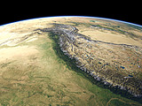
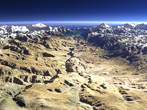
Between the Annapurna massif on the left and the Dhaulagiri on the right the Kali Gandaki river has cut a deep gorge into the main Himalayan mountain ridge. This gorge marks one of the lowest altitude crossings in the Himalayas with an elevation of just 4660m at a pass near the foreground end of this view. The upper part of the valley froms the region and former independent kingdom of Mustang which is today part of Nepal.

View: The Kali Gandaki Gorge from north
Location: Lon 84.13°
Lat 29.367°
Altitude: 13 km
Direction: 210°
Camera Angle: 46°
User Rating: -
Location Map:    Visible Topography
The Kali Gandaki Gorge from north location map
The Kali Gandaki Gorge from north

Related Views:

The Himalaya
The Himalaya in Nepal
The Kali Gandaki Gorge
Mustang

Visitor comments:

no comments yet.

Leave a comment
You have to enable Javascript to be able to write comments.
human verification Please enter the code you can see in the image on the left to verify you are a human and not a spamming script.
* * Required field
Information about you
*
will not be made public
will be displayed with your posting
Your comment (no HTML)

*

If you want to send a private message to the author of this website you can do so via Email.

The comments will be reviewed before they are added to the site. So you might need to wait some time until your entry turns up.

Please note this comment function is intended for commenting on the text and images, not for discussing political or religious views. Comments with no relation to the content of this site will not be approved.

By submitting your comment you agree to the privacy policy and agree to the information you provide (except for the email address) to be published on this website.

  
Design and Content Copyright 2023 by Christoph Hormann
last updated Sun, 16 Jul 2023 20:38