Views of the Earth

artificial images of our real planet
The Zambezi location map

The Zambezi

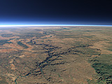
The Zambezi is the largest river in Southern Africa and famous for the Victoria Falls which are located about in the center of this view. Below the falls the river flows though a number of narrow gorges until it reaches Lake Kariba, one of the largest artificial reservoirs in the world.

View: The Zambezi
Location: Lon 28.333°
Lat -17.542°
Altitude: 59 km
Direction: 265°
Camera Angle: 38°
User Rating: 2.3
Location Map:    Visible Topography
The Zambezi location map
The Zambezi

Related Views:

The Zambezi 2

Visitor comments:

by Stretch from United Kingdom posted on Wed Apr 18 2007 11:23:16
What a stunning pic of what I knew as home years ago - a beauty that is unmatched and so different. The Zambezi Valley - natures paradise on earth. Thanks for the memories.
Leave a comment
You have to enable Javascript to be able to write comments.
human verification Please enter the code you can see in the image on the left to verify you are a human and not a spamming script.
* * Required field
Information about you
*
will not be made public
will be displayed with your posting
Your comment (no HTML)

*

If you want to send a private message to the author of this website you can do so via Email.

The comments will be reviewed before they are added to the site. So you might need to wait some time until your entry turns up.

Please note this comment function is intended for commenting on the text and images, not for discussing political or religious views. Comments with no relation to the content of this site will not be approved.

By submitting your comment you agree to the privacy policy and agree to the information you provide (except for the email address) to be published on this website.

  
Design and Content Copyright 2023 by Christoph Hormann
last updated Sun, 16 Jul 2023 20:38