Imagico.de
Geovisualizations
by Christoph Hormann
Svalbard from south
View information

View of the Archipelago of Svalbard from south with the main island Spitzbergen on the left and Edgeøya, Barentsøya, Nordaustlandet and Kvitøya on the right. Uses data from the Norwegian Polar Institute (CC-By 4.0).
| view data | |
|---|---|
| Location: | 16.944° E, 75.195° N |
| Altitude: | 111.863 km |
| View Direction: | 7° |
| Camera Angle: | 52° |
| Available size: | up to 8000×6000 pixel |
License inquiry
Blog news:
Digital map design history (16 Apr 2024)
Addresses and Entrances (11 Apr 2024)
More Antarctic images for mapping (18 Mar 2024)
Representation of mappers in OSMF membership (04 Feb 2024)
Todays featured image:
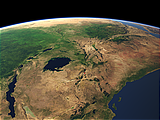
East Africa and the Great Rift
View of Eastern Africa with the Great Rift, the upper Nile river and the eastern part of the Congo Basin [more]
The most important sections:
Design and Content Copyright 2024 by Christoph Hormann
last updated Sat, 30 Mar 2024 23:52