Imagico.de
Catalog search
Search parameters
Keywords: none specified
Style: any
Minimum available size: arbitrary
Longitude: 163.5° to 180.0°, Latitude: -47.3° to -33.1°
Purpose: for licensing
Results (?)
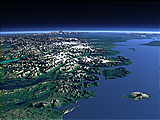
Eastern slope of the Southern Alps

Southwards view of the South Island of New Zealand onto the eastern slope of the Southern Alps with the Waimakariri and Rakaia River in the foreground and Lake Tekapo and Lake Pukaki in the background. Uses data copyright OpenStreetMap contributors and elevation data from LINZ (CC BY 3.0 NZ).
| view data | |
|---|---|
| Location: | 172.706° E, 42.653° S |
| Altitude: | 31.863 km |
| View Direction: | 240° |
| Camera Angle: | 41° |
| Available size: | up to 9600×5400 pixel |
Fiordland

View of the region of Fiordland in the southwest of New Zealand, a rugged and largely inaccessible region with a very wet climate and a unique ecosystem. Uses data copyright OpenStreetMap contributors and elevation data from LINZ (CC BY 3.0 NZ).
| view data | |
|---|---|
| Location: | 168.968° E, 44.674° S |
| Altitude: | 31.863 km |
| View Direction: | 250° |
| Camera Angle: | 61° |
| Available size: | up to 9600×5400 pixel |
The Southwest of New Zealand

View of the southwestern part of New Zealand with the southern end of the Southern Alps in the foreground and the fjords and lakes of the Fjordland region in the background. Uses data copyright OpenStreetMap contributors and elevation data from LINZ (CC BY 3.0 NZ).
| view data | |
|---|---|
| Location: | 169.179° E, 44.177° S |
| Altitude: | 35.863 km |
| View Direction: | 240° |
| Camera Angle: | 53° |
| Available size: | up to 8000×6000 pixel |
Southern New Zealand

View of the southern part of the south Island of New Zealand with the Southern Alps on the right side. Uses data copyright OpenStreetMap contributors and elevation data from LINZ (CC BY 3.0 NZ).
| view data | |
|---|---|
| Location: | 172.588° E, 42.581° S |
| Altitude: | 51.863 km |
| View Direction: | 230° |
| Camera Angle: | 53° |
| Available size: | up to 7200×9600 pixel |
The Southern Alps in New Zealand

View of the Southern Alps on the south Island of New Zealand from the north with its glaciated peaks and the lakes and the braided rivers on the eastern side. Uses data copyright OpenStreetMap contributors and elevation data from LINZ (CC BY 3.0 NZ).
| view data | |
|---|---|
| Location: | 171.005° E, 43.181° S |
| Altitude: | 51.863 km |
| View Direction: | 230° |
| Camera Angle: | 52° |
| Available size: | up to 7200×9600 pixel |
The Alpine Fault

View of the South Island of New Zealand on the west coast with the Alpine Fault prominently visible. Uses data copyright OpenStreetMap contributors and elevation data from LINZ (CC BY 3.0 NZ).
| view data | |
|---|---|
| Location: | 172.371° E, 42.125° S |
| Altitude: | 111.863 km |
| View Direction: | 220° |
| Camera Angle: | 52° |
| Available size: | up to 7200×9600 pixel |
Blog news:
Todays featured image: