Tag:natural=glacier
2022-02-18 natural=glacier |
|||
 | |||
| Glaciers and permanent land ice | |||
| GlaciologyHydrographyPhysical Geography | |||
| Tag level ⓘ | primary | ||
| Tag type ⓘ | discrete | ||
| Geometry conventions ⓘ | divisible | ||
| Closed way default ⓘ |
| ||
| Way direction significant ⓘ | no | ||
| Data quality ⓘ and volume ⓘ | |||
|---|---|---|---|
| Consistency: | good | ||
| Verifiability: | good | ||
| Geometric accuracy: | moderate | ||
| Completeness: | moderate | ||
| Feature count: | 977 | 146 | 68.0k |
| Number of nodes: | 977 | 50.3k | 8.63M |
| Nodes per feature: | – | 344.8 | 127.0 |
| Average segment length: | – | 173m | 99m |
| Total size (in km/km²): | – | 2705 | 3.61M |
| Mapping activity ⓘ | |||
| 🞼 | ྾ | 🖉 | |
| Mappers: | 1401 | 751 | 1645 |
| ⮡ since 2021-01-01: | 204 | 142 | 320 |
| Edits: | 102k | 32.8k | 25.1k |
| ⮡ since 2021-01-01: | 14.2k | 1667 | 3945 |
| Taginfo numbers and trends ⓘ | |||
| Counts: | 980 | 61.1k | 7059 |
| 30 days trend: | 2 | 346 | 3 |
| ⮡ Percent: | 0.20 | 0.57 | 0.04 |
The tag natural=glacier is used to map glaciers, that means permanent bodies of ice that formed from from snow and that are moving under their own weight, and other bodies of permanent land ice.
Practical use in OpenStreetMap is somewhat broader than the usual understanding of the definition of glacers, it often includes smaller permanent bodies of ice and firn that show no significant movement. Also included are rock glaciers. natural=glacier is not used for mapping sea ice, even where it persists over multiple years, while it is used for mapping floating parts of glaciers and ice shelves (that is permanent floating ice surfaces attached to land).
There is some use of the tag for mapping naled/aufeis at rivers in cold climate regions - but this use is not well established and there is competing more specific tagging for that.
The tag is used predominantly on polgons representing the extent of ice. To a lesser extent the tag is also used on nodes to map the existence of a glacier at a certain location when the extent of the glacier is either not mapped or the glacier is part of a larger body of ice like an ice cap or ice sheet. In a similar fashion the tag is also very rarely used on linear ways.
Polygons tagged natural=glacier are typically considered to be freely divisible according to the practical needs of mapping, in particular to characterize different parts of a glacier individually. However such divisions are rarely made, partly because many map styles render glaciers with a visible outline and an arbitrary division into several polygons can look irritating then.
There is a special convention regarding glacier mapping in the Antarctic in the form that within the Antarctic (beyond 60 degrees southern latitude) all land areas (as defined by natural=coastline) are implicitly assumed to be ice covered, unless mapped in a way otherwise that indicates a lack of ice cover.
The tags considered to override the implicit default of ice cover in the Antarctic are defined by the processes used to implement the mapping conventions for the Antarctic in map rendering. There are two processes currently available (the original icesheet_proc process and a modified process derived from that which is used to process and make available the data on a regular basis). Both processes consider all polygons with a natural=* tag to imply a lack of ice except for a list of values that differs slightly between them:
- natural=cliff
- natural=sinkhole
- natural=cave_entrance
- natural=crevasse
- natural=dune
- natural=desert
- natural=valley
- natural=volcano
- natural=coastline
- natural=bay (only on osmdata.openstreetmap.de)
These tags (as well as any other features with other tags than natural=*) are considered to be compatible with an overlapping glacier and therefore don't interfere with the implicit mapping convention for land ice in the Antarctic. This also means that glaciers can still explicitly be mapped and this superseeds the implicit default (including potentially more specific characterization with secondary tags).
natural=glacier represents, though not a high volume tag in practical use, the most significant physical classification of the earth surface and the most defining element of the Earth surface geography after the basic division between land and ocean. At the same time due to the inherent dynamics of glaciation in general it is one of the most dynamically changing elements of physical geography that needs constant update to be accurate. Due to the fact that most glaciation exists in very remote regions, glacier mapping in OpenStreetMap however does not always receive the attention it needs, especially in polar regions where most of the glaciers exist.
Secondary tags
Apart from name tags glacier mapping is rarely detailed with secondary tags. What can be found is:
- name=* on about 10 percent of features
- glacier:type=* (2.2 percent)
- surface=* (0.4 percent)
Consistency in use
natural=glacier is used with consistency overall. The most important mapping consistency issue is the lack of a clear limit to the scope of use and accordingly the quite significant use of the tag to map masses of often non-permanent snow and ice that can be seen on imagery.
Cases of mapping of snow with natural=glacier range between:
- mapping of seasonal snow based on imagery that is not taken at snow minimum. This has significantly decreased, since often more than one image source is available and mappers can cross check between different images.
- mapping of semi-permanent snow fields, i.e. places where snow tends to persist at certain places through the summer but does not form a glacier.
Examples of such cases can be seen below.
An additional problem is that debris cover on glaciers is frequently excluded from glacier mapping.
Another extraordinary use of the tag is for mapping ice cream parlors - in particular in French speaking countries where those are called glacier. This is not very common overall but has been a fairly persistent sporadic use of the tag, in particular on nodes, over the years.
In the Antarctic with the implicit mapping rules described above a special issue are small islands, in particular near the Antarctic peninsula, which are often not glaciated and which therefore would need to be mapped with a non-ice landcover (like typically natural=bare_rock), but where such tagging is missing and which are therefore by default interpreted to be glaciated.

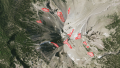
Incomplete mapping of debris covered glaciers - Eastern Greenland
Semi-permanent snowfields mapped as glaciers - Lassen Peak, image: USGS
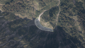
Non-permanent snowfield mapped as glacier - Eiskapelle, image: basemap.at

Naled/aufeis mapped as glacier - Batagay-Alyta


Competing tags
For the irregular use of natural=glacier to map naled/aufeis areas at rivers in very cold climate there exists a more specific tag natural=naled - which is more precise but has not gained much use so far.
Competing with use of natural=glacier for non-permanent and semi-permanent snowfields is the tag natural=snowfield.
Verifiability
Principal verifiability of natural=glacier mapping on the ground is for the lower part of glaciers that is typically snow free in summer and for the upper part. It is limited by the inherent dynamics of glaciers and by debris cover obscuring the extent of the active glacier in some cases in the lower part and all year snow cover often obscuring the extent in the upper part. Practically many glaciers are difficult to access on the ground which practically makes local assessment difficult.
Verifiability for remote mapping is fairly similar, but practically often more difficult, because it depends on images depicting the snow minimum. Additionally, many glaciers are located in parts of the world where good imagery can be difficult to find.
As glaciers predominantly occur in remote regions, many mappers lack deeper familiarity with their characteristics and, as a result, have difficulty to properly assess and map them - either locally or remotely.
Geometric accuracy and Completeness
Geometric accuracy of mapping of glaciers is overall on a level, but varies greatly between different parts of the world. In most parts of the world mapping of glaciers is performed by relatively few mappers and data import and these define the accuracy of the data. An overall assessment of different regions of glaciation can be found below.
Overall completeness is also but again varies a lot between regions.
| Region | Geometric accuracy | Completeness | Import? | Notes |
|---|---|---|---|---|
| Antarctic | yes | fairly old data | ||
| Greenland | no | mostly old hand mapping based on poor imagery from 1999-2003 | ||
| Canadian Arctic | yes | partial Canvec imports based on old surveys | ||
| Svalbard | yes | partial NPI imports mixed with partial hand mapping, highly incomplete | ||
| Russian Arctic | no | systematic and fairly complete mapping of the islands except Novaya Zemlya - which is very incomplete | ||
| Iceland | no | |||
| Norway | yes | Imported data is detailed but in parts very old | ||
| Northern Asia | no | Fairly extensive and detailed manual mapping but with significant gaps | ||
| Alps | no | Probably the best mapped region in terms of glacier mapping | ||
| Caucasus | no | |||
| Central Asia/Himalayas/Tibet | no | locally in parts fairly accurate mapping but with huge gaps | ||
| North America | yes | partical imports combined with variable quality hand mapping. Quite incomplete. | ||
| South America | no | existing mapping is mostly of fairly decent accuracy - but incomplete, especially in the very south. | ||
| New Zealand | yes | imported data is detailed but in large parts very outdated | ||
| Subantarctic Islands | no |
History of use
Glacier mapping in OpenStreetMap started very early and - especially in polar regions - was often done based on old imagery, meaning that the mapping in parts represents a state more than 20 years old. Only in few areas (mostly Alps and Caucasus) mapping activities maintain and update the data routinely to document the changes in glaciation.
On the other hand, mapping has expanded quite a bit in recent years with more extensive availability of good quality imagery in remote regions, leading to mapping activity in particular in the Himalaya/Tibet/Central Asia region, on Iceland and on the Subantarctic islands.
Substantial amounts of glacier data have also been imported from external sources over the years, in particular in the Antarctic in 2013, in Canada, in New Zealand and more recently in Norway. In some cases the imported data was already outdated at the time of import and accordingly is not very accurate. Where data imports were done in full over an area, however, coverage is usually fairly complete.
The implicit glacier mapping convention for the Antarctic was introduced in 2013 in the course of imports.
Analysis maps
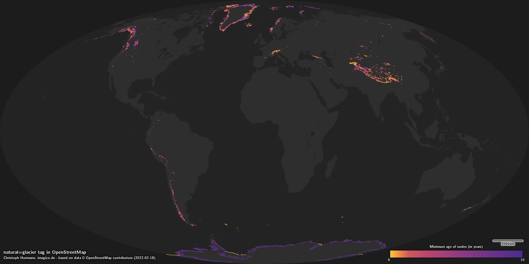 |
| Minimum age of nodes |
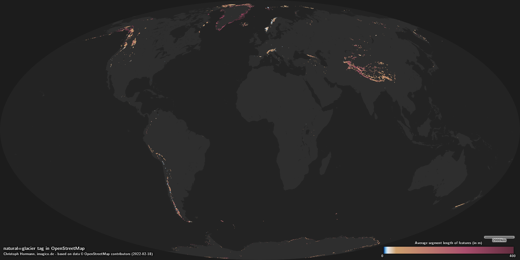 |
| Average segment length |
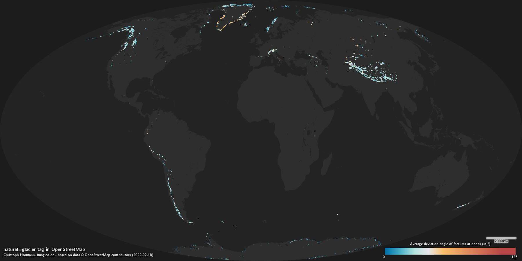 |
| Average deviation angle |
Rendering
Almost all OpenStreetMap based maps render the ocean as defined by the coastline with a plain color or pattern fill, most in the same color/pattern as inland water areas.


 |
| z7 |
 |
| z8 |
 |
| z9 |
 |
| z10 |
 |
| z11 |
 |
| z12 |
 |
| z13 |
 |
| z14 |
 |
| z15 |
 |
| z16 |
 |
| z17 |
 |
| z18 |
 |
| z19 |
 |
| z7 |
 |
| z8 |
 |
| z9 |
 |
| z10 |
 |
| z11 |
 |
| z12 |
 |
| z13 |
 |
| z14 |
 |
| z15 |
 |
| z16 |
 |
| z17 |
 |
| z18 |
 |
| z19 |


- Glaciology tags
- Hydrography tags
- Physical Geography tags
- Primary Tags
- Discrete Classification Tags
- Divisible geometry features
- Tags where way direction is not significant
- Tags with good consistency
- Tags with good verifiability
- Tags with moderate geometric accuracy
- Tags with moderate completeness
- Tags
- Tags with maps
- Tags with rendering samples