Tag:natural=peak
2022-02-16 natural=peak |
|||
 | |||
| Local elevation maximum of the earth surface | |||
| TopographyPhysical Geography | |||
| Tag level ⓘ | primary | ||
| Tag type ⓘ | discrete | ||
| Geometry conventions ⓘ | singular | ||
| Closed way default ⓘ |
| ||
| Way direction significant ⓘ | no | ||
| Data quality ⓘ and volume ⓘ | |||
|---|---|---|---|
| Consistency: | good | ||
| Verifiability: | excellent | ||
| Geometric accuracy: | good | ||
| Completeness: | moderate | ||
| Feature count: | 796k | 108 | 10 |
| Number of nodes: | 796k | 108 | 10 |
| Nodes per feature: | – | 1.0 | 1.0 |
| Average segment length: | – | ||
| Total size (in km/km²): | – | ||
| Mapping activity ⓘ | |||
| 🞼 | ྾ | 🖉 | |
| Mappers: | 21.5k | 9008 | 22.5k |
| ⮡ since 2021-01-01: | 3848 | 1405 | 4680 |
| Edits: | 1000k | 206k | 647k |
| ⮡ since 2021-01-01: | 125k | 11.4k | 128k |
| Taginfo numbers and trends ⓘ | |||
| Counts: | 798k | 113 | 13 |
| 30 days trend: | 7253 | 2 | 0 |
| ⮡ Percent: | 0.91 | 1.77 | 0.00 |
The tag natural=peak is used to map local highpoints in the earth surface topography. This can be named and prominent mountain peaks but also any unnamed protusion in terrain. The tag is essentially only used on nodes.
natural=peak is the most widely mapped topography feature in OpenStreetMap and the most widely mapped feature that is predominantly mapped in three dimensions by having an ele=* value tagged.
Secondary tags
Non-metadata secondary tags that can frequently be found on peaks are:
- ele=* on about 68 percent of features
- name=* on about 65 percent of features - the most common other name tags are name:en=*, alt_name=*, name:de=*, name:ar=*, name:fr=* and int_name=*
Consistency in use
natural=peak is used with consistency. There is very little use of the tag outside its main field of use but there is significant overlap with competing tags - which for natural=volcano also concerns fairly prominent peaks.
Competing tags
There is a separate tag natural=hill that was created for mapping peaks that are in some way less articulated in a distinct fashion but there is no clear separation towards natural=peak and this tag essentially covers a vaguely defined subset of what is more commonly tagged natural=peak.
natural=volcano overlaps in use with natural=peak as well, it is widely used for peaks of volcanic origin but at the same time also for volcanic features of various kinds.
Verifiability
Verifiability of natural=peak mapping on the ground is .
Poorly articulated peaks can - especially in densely forested areas of from imagery with high sun position and therefore little shading of the terrain - be difficult to verify from imagery.
Geometric accuracy
Geometric accuracy of peak locations is typically . Of negative impact on this are in particular offsets in imagery used for mapping. Typical high resolution satellite imagery is often poorly orthorectified and as a result is subject to significant offsets in mountain areas. This leads to errors in peak locations mapped from such images. Similar errors can result from imports of peak location from older and low accuracy sources. Examples can be seen below.

Peak location mapped with a significant offset relativel to local imagery - Sweden, image: Lantmäteriet
Peak location from old topographic maps with offset relative to elevation data set - Alaska, image: USGS
Imported peak locations with offset - Greenland


Completeness
Since natural=peak can be used for any local highpoints of the topography, specifying an overall level of completeness is not possible. If we rank peaks by topographic prominence we have on the level of Ultras (>1500m prominence) an level of completeness. This drops to levels probably already above 200m prominence.
Analysis maps
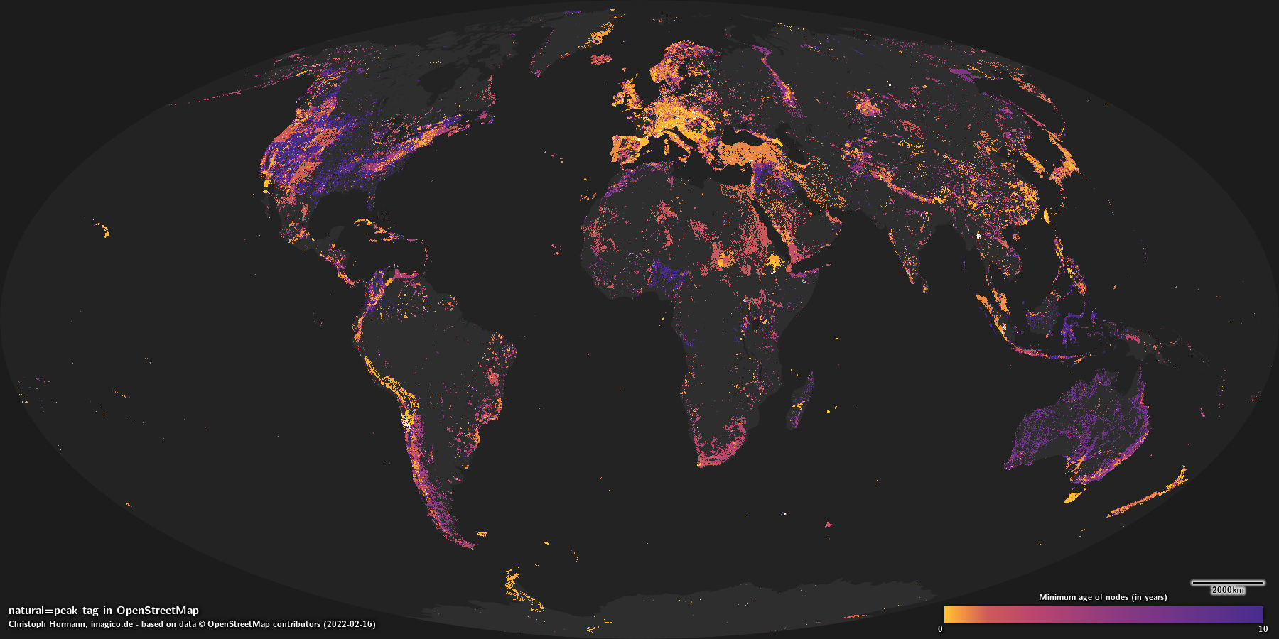 |
| Minimum age of nodes |
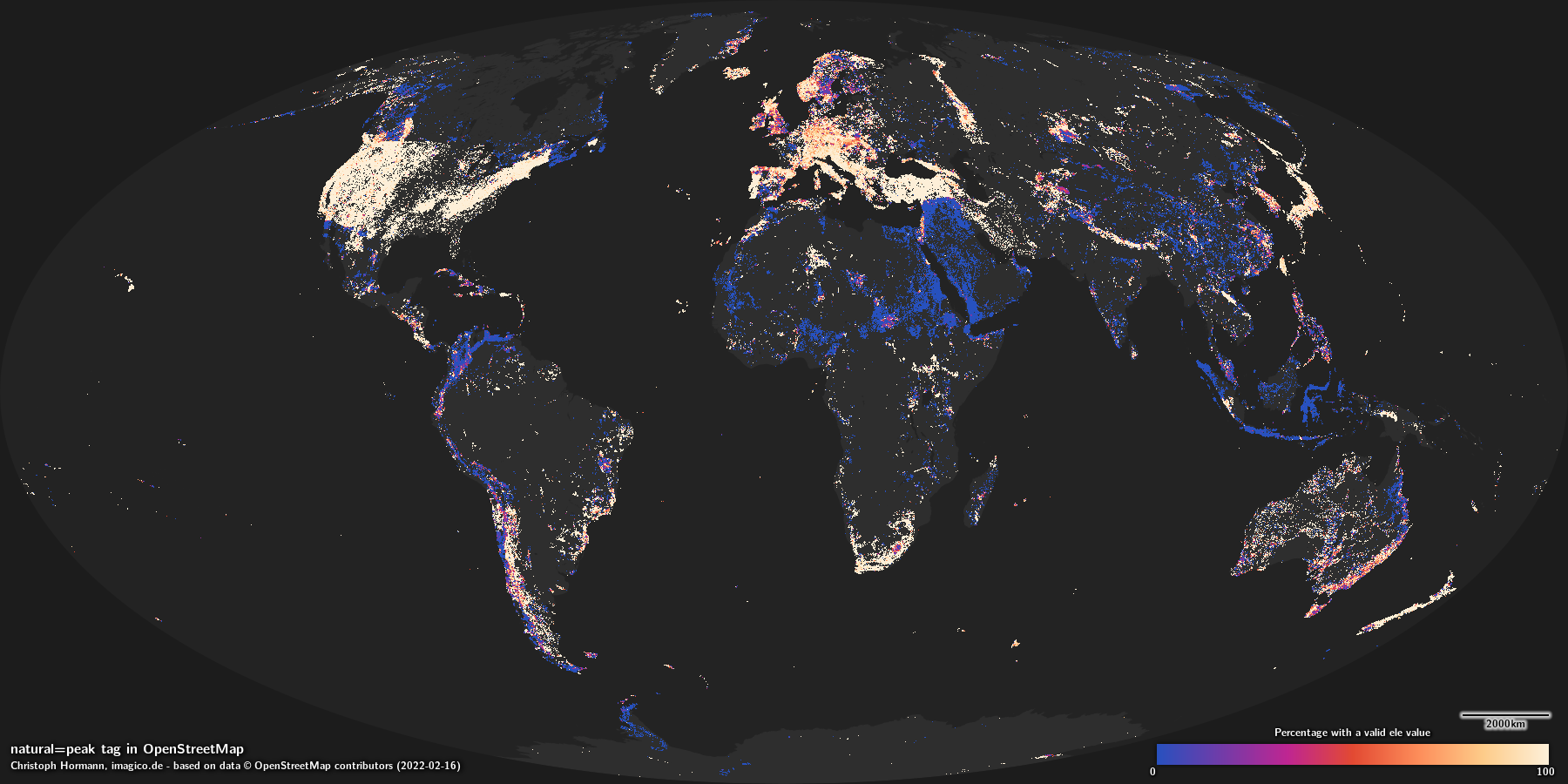 |
| Percentage of features with an ele=* tag |
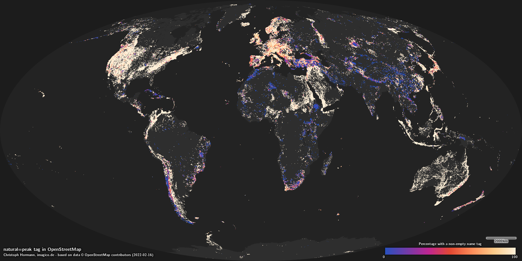 |
| Percentage of features with a name=* tag |
Rendering


 |
| z11 |
 |
| z12 |
 |
| z13 |
 |
| z14 |
 |
| z15 |
 |
| z16 |
 |
| z17 |
 |
| z18 |
 |
| z19 |
- Topography tags
- Physical Geography tags
- Primary Tags
- Discrete Classification Tags
- Singular geometry features
- Tags where way direction is not significant
- Tags with good consistency
- Tags with excellent verifiability
- Tags with good geometric accuracy
- Tags with moderate completeness
- Tags
- Tags with maps
- Tags with rendering samples