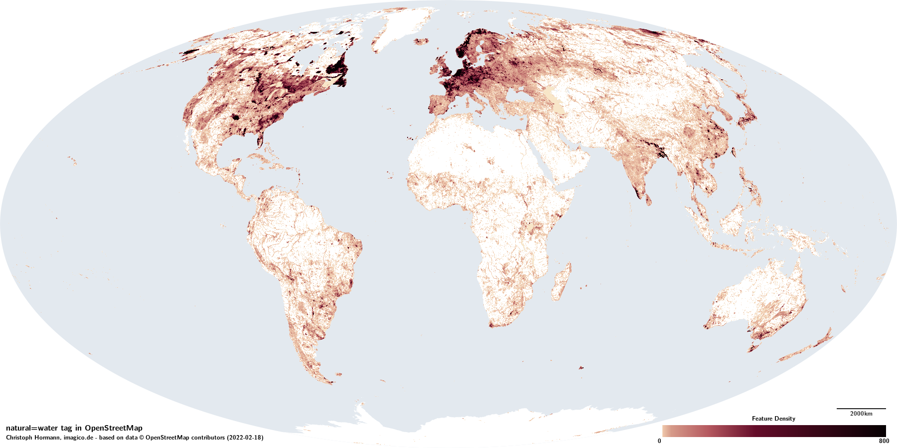
The tag natural=water is used to map permanently or regularly water covered parts of the Earth surface that are not and are not part of maritime waterbodies.
This includes standing waterbodies - both naturally occurring and artificial - as well as the water covered areas of rivers and canals. natural=water is used typically only for surface waterbodies, underground water features are not commonly mapped using this tag. Also included are open pools or containers with contaminated/polluted water. Not tagged with natural=water typically are swimming pools (for which there is a separate tag leisure=swimming_pool). Also the tag is strictly limited to liquid waterbodies (but including permanently frozen lakes). Bodies of permanent ice are instead mapped with natural=glacier.
The tag is used predominantly on polgons that represent the water covered area. In a much smaller volume it is also used on nodes to map the existence of a waterbody at a certain location when the extent of the waterbody is not mapped. A large fraction of these nodes is coming from imports. The tag is not used on linear ways in a meaningful way.
The conventions on dividing polygons tagged natural=water depend on the type of waterbody mapped. Standing waterbodies are typically mapped with a single polygon. The identity of the waterbody in this case does not primarily derive from the physical geography but from the local naming conventions (like Lake Michigan–Huron). Where physical characteristics differ between parts of the same waterbody (like Lake Balkhash) split geometries are accepted. Combining several disjunct waterbodies into a single multipolygon feature on the other hand is very uncommon. For the water covered areas of rivers and canals polygon mapping is considererd fully dividible to the convenience of the mapper.
natural=water is a very widely used tag and accounts for nearly five percent of the total data volume in OpenStreetMap. It represents a fairly fundamental element of the geography. At the same time it only carries very basic information saying essentially nothing more than "here is water". More specific and differentiated information is recorded only in secondary tags - which however are only recorded on about one third of the features.
Secondary tags
Commonly used non-metadata secondary tags on features tagged natural=water are:
- water=* on about 29 percent of features, most commonly:
Consistency in use
natural=water is used with mostly excellent consistency for permanent standing waterbodies with relatively constant water levels with the exception of competing tags for reservoirs as described below.
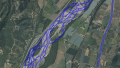
typical splits in riverbank mapping
For the water covered areas of rivers there is likewise competing alternative tagging but also also there is not really a consistent practice when rivers are mapped with riverbank polygons and when not. The primary mapping of rivers is broadly considered to be the centerline mapping with waterway=river. Riverbank polygon mapping is considered to be supplemental to that. Wider rivers tend to be more frequently mapped with riverbank polygon but there is no consistent practice in that which can be relied upon even just within smaller regions. There is also no clear agreement whether for a river or canal with constant width a waterway centerline with a width=* tag makes mapping a riverbank polygon superfluous or not.
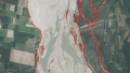
The divisions in mapping of riverbank polygons also do not follow a uniform convention. While small segments like in the example shown with a length of up to 20-50 times the width of the river are the most common practice of splitting, there are also frequently much larger polygons - right up to creating polygons along the whole extent of a river across hundreds of kilometers. There is also no consistent match between individual features of the river centerline and individual riverbank polygon features. Both are split independently of each other. Name tags are generally not considered to belong to the water covered area polygons but to the river centerline mapping, however they are still widely tagged on the polygons and many map styles render labels on all natural=water polygons. Overall consistency in mapping of flowing waterbodies with natural=water polygons can be considered to be moderate.
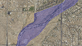
For non-permanent and variable water level waterbodies consistency is even lower (moderate to bad). There is no broadly accepted rule how variable water level waterbodies are to be mapped. There is a general tendency to map them at the high water level rather than the low level. This can reach extreme levels in case of braided rivers where the whole floodplain is sometimes mapped uniformly with natural=water because over the course of several years all parts of it will at some point be water covered although it is never fully water covered at the same time. In some parts of the world (in particular in Canada, to some extent also New Zealand) this is also the result of misclassification of imported data.
For non-permanently water covered areas there are the secondary tags intermittent=yes and seasonal=yes which are typically applied to the whole waterbody. Splitting of water areas into permanent and non-permanent parts is not a very frequent practice but it does happen, like for example in case of Lake Mead, or sometimes in case of braided rivers. It is not uncommon for the riverbank polygon and the waterway line to have different intermittent=* tagging and there is no clarity if such tagging can have a significant meaning.
natural=water also sees some use in the mapping of dry lakebeds/hardpans/playas with no verifiable present day surface water cover or for the generally non-verifiable extent of areas subject to rare ephemeral flooding. The latter is limited to arid regions, such use of the tag is not common in more humid areas.
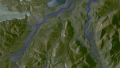
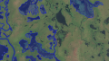
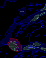
Separate mapping of permanently and intermittent water cover - Dranse, image: swisstopo
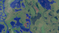
Wrong classification of whole floodplains as intermittent water from imports - Ellesmere Island
Non-verifiable mapping of a flood prone area around an ephemeral river - Cañada del Oro, image: USGS
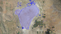
Mapping of a permanently dry playa as intermittent water - Willcox Playa, image: USGS
Competing tags
Competing tags for water covered areas exist for some artificial waterbodies and rivers:
- waterway=riverbank has historically been the dominant primary tag for the water covered areas of rivers. It has reduced in use, partly due to concerted efforts to eliminate its use, but there are quite a few mappers who prefer to make the distinction between flowing and standing water in the primary tag.
- landuse=reservoir and landuse=basin have historically been the dominant primary tag for artificial waterbodies being created for water storage or management of some kind. They are still somewhat popular in use as well.
For non-permanently water covered areas there is also some use of natural=wetland and natural=mud.
Verifiability
Verifiability of natural=water mapping on the ground is typically excellent when the water levels are relatively constant over time. For waterbodies with varying levels the lower limit (or in other words: the extent of the permanently water covered area) tends to be hard to verify practically. The upper limit or the extent of the intermittently water covered area is better verifiable based on traces of water cover on the ground, at least for areas with regular water cover. For less frequent, ephemeral water cover this is more difficult. Overall the verifiability of variable level/intermittent water cover can be considered to be moderate (regular, seasonal water cover) to bad (ephemeral water cover).
Verifiability for remote mapping can be difficult even for permanent waterbodies due to vegetation cover. This systematically limits remote mapping in densely forested areas to larger waterbodies. Availability of infrared imagery can massively improve the ability of mappers to identify waterbodies.
For non-permanent waterbodies verifiability is often bad and that is frequently the cause of incorrect mapping. Factors that can help here are:
- local knowledge and ground level images
- images from different seasons in case of seasonal water cover
- generally the availability of multiple images from different dates to assess the dynamics of the area
- infrared imagery for clearer identification of shallow water cover
Geometric accuracy
Geometric accuracy of mapping of waterbodies is overall on a good level but varies greatly between different parts of the world. The main causes for inaccuracies are:
- Coarse, approximative mapping. This is common in some remote areas but mostly concerns fairly old mapping and is fairly rare these days for newer data, To some extent lower quality imports (Canadian Canvec, US NHD) are also affected by this.
- Systematic overstatment of the extent of water cover based on wrong reading of imagery or incorrect assumption of a larger high water extent. This as already explained above is a fairly common problem for riverbank polygons and it is widespread even in generally accurately mapped regions.
- Misjudgement of the water cover extent due to vegetation cover or dry season imagery.
- Outdated mapping of waterbodies changing their shape, in particular shifting river beds.
Completeness
Overall mapping of standing water areas is fairly good globally, even in remote regions with very little being mapped otherwise basic water cover mapping tends to be something that happens early. The biggest large scale systematic gaps in waterbody mapping exist in northern Canada where there are continuous complete gaps in lake mapping over more than 10000 square kilometers and lakes more than ten kilometers in extent are completely missing.
Smaller gaps are common in other more remote areas, in particular in Alaska, Russia and in tropical regions.
Mapping of the water covered areas of rivers is - as mentioned above - less uniform since it is generally considered supplemental to the primary mapping with linear waterway lines. Even in densely mapped areas in Europe there are many larger rivers (more than 20 meters wide) where there is no riverbank polygon mapped.
History of use
Historically the use of natural=water was much more narrow, essentially limited to lakes and smaller artificial waterbodies. Riverbank polygons with their very different mapping conventions as well as reservoirs were tagged with different primary tags.
Motives for extending the application of natural=water to all surface water cover were predominantly
- The wish to separate basic recoding of water cover from more specific information on the nature of the waterbody, to be able to record water cover without knowledge of its nature and to be able to import data from external sources with different data models where the smallest common denominator is the water cover information.
- The aim to create a more systematically structured tagging system.
- The aim to simplify data interpretation for data users only interested in basic water cover data.
- To fix gaps in the tagging system, in particular the lack of a tag to map the water covered area of a canal.
The idea to use natural=water for any kind of waterbody was first introduced in 2011 with a proposal for water=* tags. This was adopted for the more specific tagging of waterbodies that were previously just plainly tagged natural=water but riverbank polygons continued to be predominantly tagged waterway=riverbank. In 2019 a systematic retagging campaign was organized and implemented that led to the elimination of waterway=riverbank almost world wide - except in those countries where the local community actively opposed systematic retagging.
As a cause of this about 300k of the 360k features tagged natural=water + water=river are the result of systematic retagging.
Large scale imports of water polygon data have been performed in Canada, the United States, New Zealand, Norway, the Netherlands and the Czech Republic.
Another specialty of waterbody mapping is that a significant number of geometries have been generated with the help of tools like scanaerial from imagery, i.e. through supervised automated geometry generation where the mapper clicks on a lake and an algorithm estimates the geometry of the water surface around this point by analyzing the imagery used.
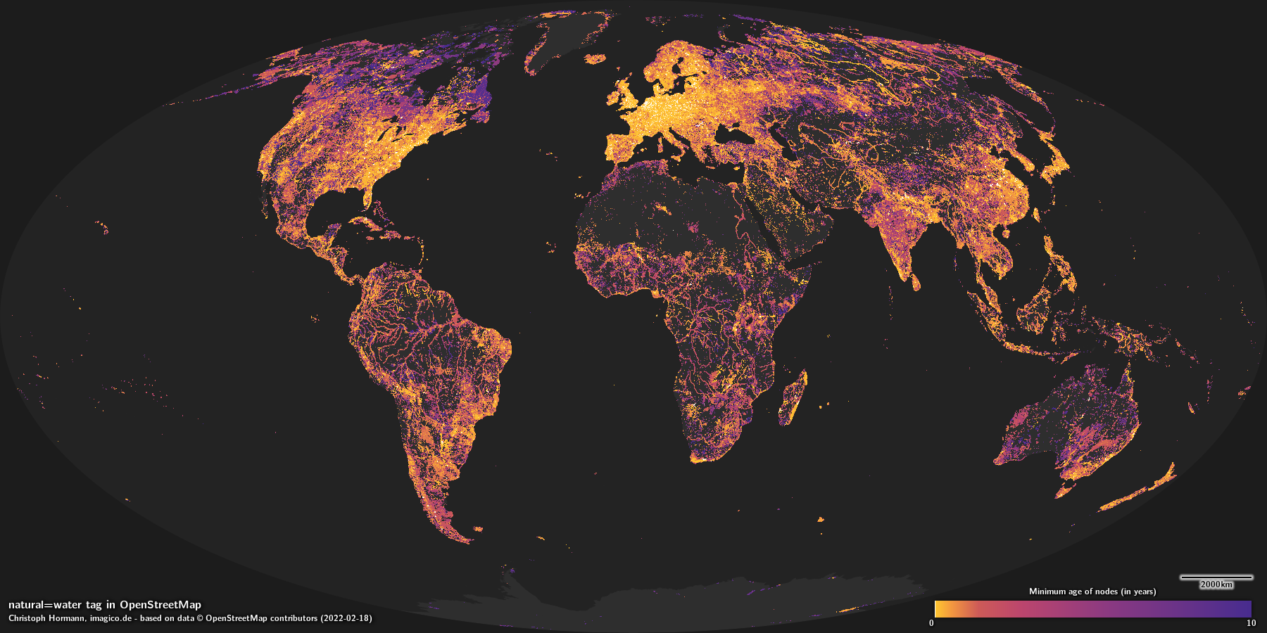
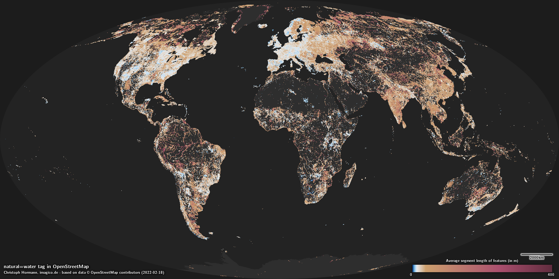
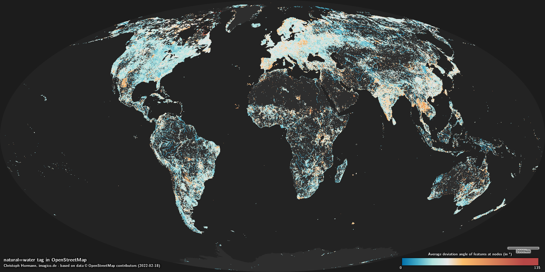
Analysis maps
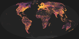 |
| Minimum age of nodes |
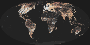 |
| Average segment length |
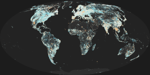 |
| Average deviation angle |
Rendering
Almost all OpenStreetMap based maps render natural=water polygon features with a plain color or pattern fill, most in the same color/pattern as the ocean. Many apply also polygon size filtering - which works poorly on divisable geometries. Some render name labels as well. Outlines on water features can be found only rarely because of the difficulties implementing this in good quality with adjacent polygons. Distinct rendering of intermittent water areas is also rare.