Difference between revisions of "Template:TagInfoBox"
Jump to navigation
Jump to search
(Make mapping activity data optional) |
|||
| Line 1: | Line 1: | ||
<includeonly><table class="tagdoc-infobox"> | <includeonly><table class="tagdoc-infobox"> | ||
<tr> | <tr> | ||
<td colspan="4"><div class="tagdoc-ibox-date" title="data analysis as of this date">{{{date}}}</div><div class="tagdoc-ibox-heading tagdoc-ibox-heading-{{{level}}}">'''{{{key}}}= | <td colspan="4"><div class="tagdoc-ibox-date" title="data analysis as of this date">{{{date}}}</div><div class="tagdoc-ibox-heading tagdoc-ibox-heading-{{{level}}}">'''{{{key}}}={{{value|*}}}</div></td> | ||
</tr> | </tr> | ||
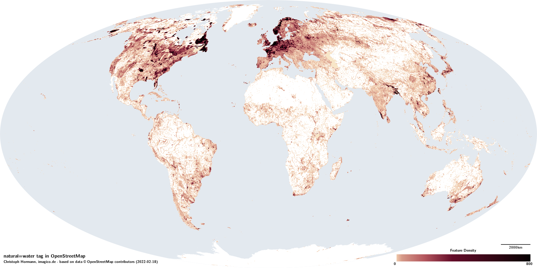
<tr><td colspan="4" class="tagdoc-ibox-map"><span class="plainlinks" title="density distribution of features with this tag">[https://imagico.de/tag_data/{{{key}}}{{#if: {{{value|}}}|_{{{value}}}}}/density_map.png https://imagico.de/tag_data/{{{key}}}{{#if: {{{value|}}}|_{{{value}}}}}/density_map_small.png]</span></td></tr> | <tr><td colspan="4" class="tagdoc-ibox-map"><span class="plainlinks" title="density distribution of features with this tag">[https://imagico.de/tag_data/{{{key}}}{{#if: {{{value|}}}|_{{{value}}}}}/density_map.png https://imagico.de/tag_data/{{{key}}}{{#if: {{{value|}}}|_{{{value}}}}}/density_map_small.png]</span></td></tr> | ||
Revision as of 01:54, 4 March 2022
Template to display the right side info box on a tag page. Like:
2022-02-18 natural=water |
|||
 | |||
| Permanently or regularly water covered part of the Earth surface | |||
| Hydrography Physical Geography | |||
| Tag level ⓘ | primary | ||
| Tag type ⓘ | discrete | ||
| Geometry conventions ⓘ | mixed | ||
| When used with: | |||
| ⮡ water=river | divisible | ||
| ⮡ water=lake | singular | ||
| Closed way default ⓘ |
| ||
| Way direction significant ⓘ | no | ||
| Data quality and volume | |||
|---|---|---|---|
| Consistency: | + | ྾ | ~ |
| Verifiability: | − | 🞼 | 🞼 |
| Geometric accuracy: | good | ||
| Completeness: | good | ||
| Feature count: ⓘ | 22.3k | 14.8k | 11.9M |
| Number of nodes: ⓘ | 22.3k | 629k | 498M |
| Nodes per feature: ⓘ | – | 42.6 | 42.0 |
| Average segment length: ⓘ | – | 16m | 24m |
| Total size (in km/km²): ⓘ | – | 14.0k | 3.30M |
| Mapping activity | |||
| 🞼 | ྾ | 🖉 | |
| Mappers: ⓘ | 118k | 43.1k | 95.1k |
| ⮡ since 2021-01-01: | 20.8k | 8636 | 19.5k |
| Edits: ⓘ | 13.9M | 2.02M | 2.02M |
| ⮡ since 2021-01-01: | 1.54M | 480k | - |
| Taginfo numbers and trends | |||
| Counts: ⓘ | 22.4k | 11.3M | 610k |
| 30 days trend: ⓘ | 398 | 61.3k | 2455 |
| ⮡ Percent: ⓘ | 1.78 | 0.54 | 0.40 |