Difference between revisions of "Tag:natural=coastline"
m |
(Adding commas, fixing typos.) |
||
| Line 80: | Line 80: | ||
}} | }} | ||
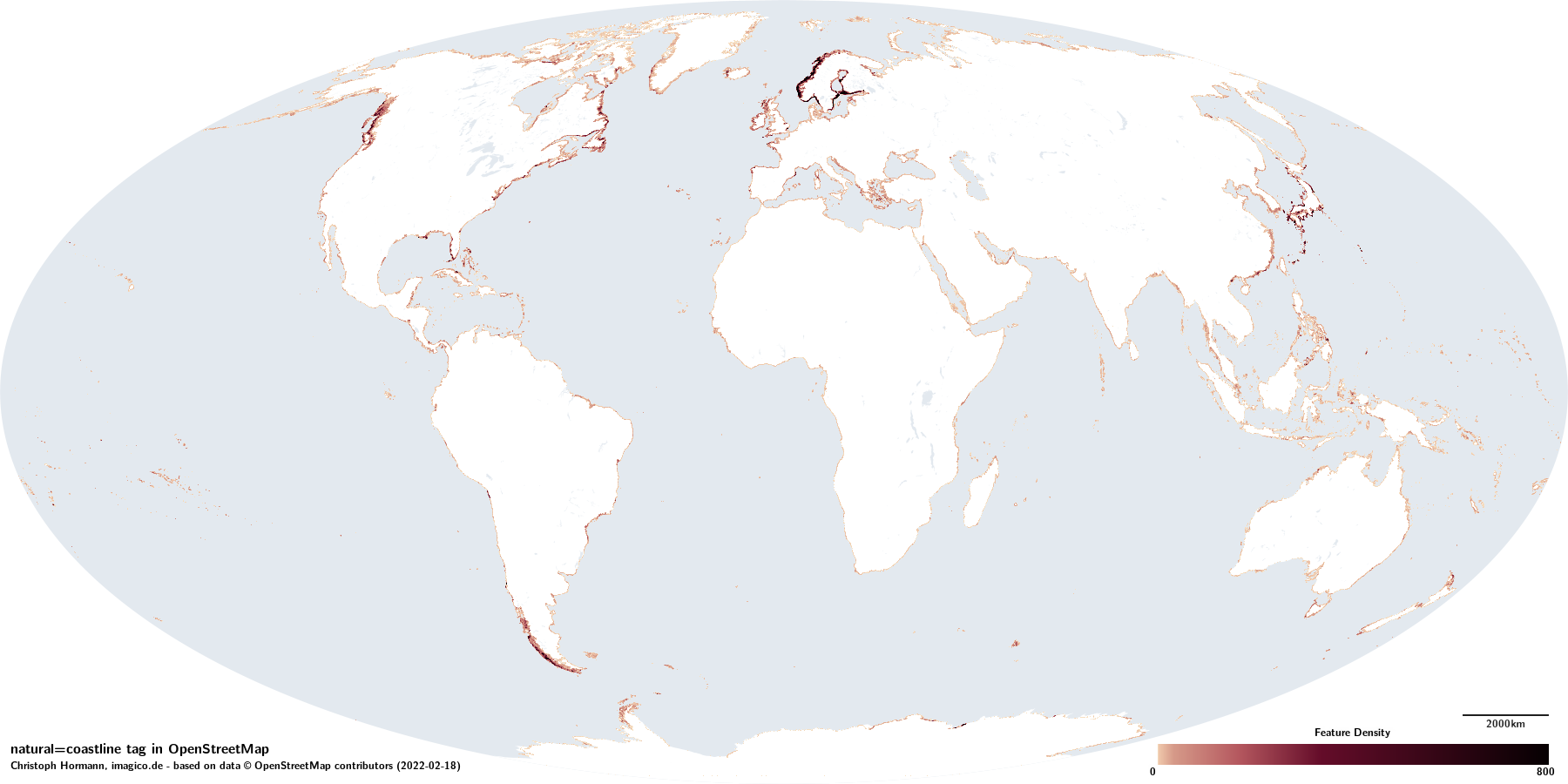
The tag {{Tag|natural|coastline}} is used to delineate the world ocean from land and inland water areas. By historically established convention this is done at the high limit of the tidal cycle. | The tag {{Tag|natural|coastline}} is used to delineate the world ocean from land and inland water areas. By historically established convention, this is done at the high limit of the tidal cycle. | ||
The {{Location|Caspian Sea|5/41.459/47.000}}} is the only waterbody without level connection and water exchange with the world ocean that is also mapped with {{Tag|natural|coastline}}. | The {{Location|Caspian Sea|5/41.459/47.000}}} is the only waterbody without level connection and water exchange with the world ocean that is also mapped with {{Tag|natural|coastline}}. | ||
| Line 88: | Line 88: | ||
No distinction in tagging of the coastline is made to indicate if a certain section of it has naturally formed or if it has been created artificially - like for example in case of the edge of a dam or breakwater. | No distinction in tagging of the coastline is made to indicate if a certain section of it has naturally formed or if it has been created artificially - like for example in case of the edge of a dam or breakwater. | ||
The coastline tag in unique in OpenStreetMap in the way that it is not usually interpreted locally but by assembling all coastline ways | The coastline tag in unique in OpenStreetMap in the way that it is not usually interpreted locally, but by assembling all coastline ways worldwide into polygons either representing the land surfaces of continents and islands or the ocean, using a program called [https://osmcode.org/osmcoastline/ OSMCoastline]. | ||
{{Assessment|The coastline mapping with {{Tag|natural|coastline}} represents the most fundamental structuring of the planet surface and its documentation in the OSM database. Owed to this and to the fact that the global processing of the coastline data mandates a global perspective on mapping the coastline is at the moment the most uniformly mapped element of the geography in OpenStreetMap.}} | {{Assessment|The coastline mapping with {{Tag|natural|coastline}} represents the most fundamental structuring of the planet surface and its documentation in the OSM database. Owed to this, and to the fact that the global processing of the coastline data mandates a global perspective on mapping the coastline, is - at the moment - the most uniformly mapped element of the geography in OpenStreetMap.}} | ||
== Secondary tags == | == Secondary tags == | ||
There are no secondary tags commonly used in combination with {{Tag|natural|coastline}} except for {{Tag|coastline|bogus}} - which is used for the segments closing the coastline in the Antarctic (see below). The ways with the coastline tags are however widely used to represent polygon geometries of smaller islands. Such use is generally considered completely independent of the coastline mapping and for example a closed way tagged {{Tag|natural|coastline}} and {{Tag|place|island}} can function both as a polygon geometry for the island and as a linear way representing the coastline. Since the interpretation of coastline data is technically separate from other data interpretation there are typically no problems resulting from such reuse of the way geometry. | There are no secondary tags commonly used in combination with {{Tag|natural|coastline}} except for {{Tag|coastline|bogus}} - which is used for the segments closing the coastline in the Antarctic (see below). The ways with the coastline tags are, however, widely used to represent polygon geometries of smaller islands. Such use is generally considered completely independent of the coastline mapping and, for example, a closed way tagged {{Tag|natural|coastline}} and {{Tag|place|island}} can function both as a polygon geometry for the island and as a linear way representing the coastline. Since the interpretation of coastline data is technically separate from other data interpretation, there are typically no problems resulting from such reuse of the way geometry. | ||
== Consistency in use == | == Consistency in use == | ||
| Line 102: | Line 102: | ||
* That coastline tag is used exclusively on ways. | * That coastline tag is used exclusively on ways. | ||
* That coastline ways are oriented consistently so that water is to the right side of the coastline and land is to the left. | * That coastline ways are oriented consistently so that water is to the right side of the coastline and land is to the left. | ||
* That | * That coastline ways form continuous rings around islands and continents without gaps or intersections in Equirectangular projection (i.e. geographic coordinates interpreted as cartesian). With the exception of the Antarctic coastline, which can be closed automatically by OSMCoastline. | ||
The consistency of use of the tag with the described meaning is {{InlineRating|excellent}} as well in most parts of the world where the coastline represents the boundary between ocean and land. There are some regions however where maritime waterbodies are to some extent mapped on the land side of the coastline. This is the case in particular at the {{Location|North American east coast|9/38.0794/-76.0680}} and in parts of the {{Location|West African coast|9/11.3656/-15.7503}}. | The consistency of use of the tag with the described meaning is {{InlineRating|excellent}} as well in most parts of the world where the coastline represents the boundary between ocean and land. There are some regions however, where maritime waterbodies are to some extent mapped on the land side of the coastline. This is the case in particular at the {{Location|North American east coast|9/38.0794/-76.0680}} and in parts of the {{Location|West African coast|9/11.3656/-15.7503}}. | ||
Less consistent ({{InlineRating|moderate}} to {{InlineRating|bad}}) is the placement in case where the coastline draws a line between ocean and inland water. Here the choice of placement is often not based on verifiable characteristics of the physical geography but derives from local cultural conventions or is simply the result of an arbitrary choice by the mapper. There is also some practice of ocean mapping with {{Tag|natural|coastline}} and inland water mapping with {{Tag|natural|water}} overlapping. | Less consistent ({{InlineRating|moderate}} to {{InlineRating|bad}}) is the placement in case where the coastline draws a line between ocean and inland water. Here the choice of placement is often not based on verifiable characteristics of the physical geography but derives from local cultural conventions or is simply the result of an arbitrary choice by the mapper. There is also some practice of ocean mapping with {{Tag|natural|coastline}} and inland water mapping with {{Tag|natural|water}} overlapping. | ||
| Line 125: | Line 125: | ||
== Verifiability == | == Verifiability == | ||
Verifiability of {{Tag|natural|coastline}} mapping on the ground is typically {{InlineRating|excellent}}. Even when observing the coast at low tide it is usually well possible to assess the high tide limit from indications for recent water cover. | Verifiability of {{Tag|natural|coastline}} mapping on the ground is typically {{InlineRating|excellent}}. Even when observing the coast at low tide, it is usually well possible to assess the high tide limit from indications for recent water cover. | ||
Verifiability for remote mapping from imagery can be more difficult. This in particular applies in areas with vegetation cover or with a significant tidal range. Availability of imagery depicting different tidal levels can be an important factor to help with accurate mapping. | Verifiability for remote mapping from imagery can be more difficult. This in particular applies in areas with vegetation cover or with a significant tidal range. Availability of imagery depicting different tidal levels can be an important factor to help with accurate mapping. | ||
| Line 131: | Line 131: | ||
== Geometric accuracy == | == Geometric accuracy == | ||
The difficulty in determining the exact coastline position in remote mapping has | The difficulty in determining the exact coastline position in remote mapping has led to coastlines sometimes being systematically off, depending on the image sources and mapping processes used. | ||
* some areas (like with remaining data from PGS imports - see below) have the coastline being systematically placed too high due to for example wetlands and seasonal water cover being misclassified as outside the coastline. | * some areas (like with remaining data from PGS imports - see below) have the coastline being systematically placed too high due to, for example, wetlands and seasonal water cover being misclassified as outside the coastline. | ||
* in areas where commonly used imagery shows an intermediate water level during the tidal cycle the coastline is frequently placed at where the image shows the water edge rather than at the high tide limit. | * in areas where commonly used imagery shows an intermediate water level during the tidal cycle, the coastline is frequently placed at where the image shows the water edge rather than at the high tide limit. | ||
The second of these two cases typically results in relatively small errors while the first can be the cause of fairly large errors in some cases. This can be observed for example at the {{Location|Indus Delta/Rann of Kutch|10/24.0295/67.7959}} or at the {{Location|West Australian coast|11/-22.1267/114.4861}} | The second of these two cases typically results in relatively small errors, while the first can be the cause of fairly large errors in some cases. This can be observed for example at the {{Location|Indus Delta/Rann of Kutch|10/24.0295/67.7959}} or at the {{Location|West Australian coast|11/-22.1267/114.4861}} | ||
Apart from these cases of systematic misplacement the biggest geometric errors in coastline mapping exist in polar regions with rapidly changing coastline positions and out-of-date mapping. | Apart from these cases of systematic misplacement, the biggest geometric errors in coastline mapping exist in polar regions with rapidly changing coastline positions and out-of-date mapping. | ||
<gallery> | <gallery> | ||
| Line 168: | Line 168: | ||
== History of use == | == History of use == | ||
Coastline mapping in OpenStreetMap started very early and before the currently used OSMCoastline process was developed. Originally {{Tag|natural|coastline}} was not only used for seashore mapping bus also for large inland waterbodies. This use was step by step reduced over the years and is | Coastline mapping in OpenStreetMap started very early and before the currently used OSMCoastline process was developed. Originally, {{Tag|natural|coastline}} was not only used for seashore mapping bus also for large inland waterbodies. This use was step by step reduced over the years and is generally not practiced any more - with the mentioned exception of the Caspian Sea. | ||
For significant parts of the world [[OSMWiki:PGS|PGS]] data was imported early on and parts of this data still remain in some more remote parts of the planet - with the mentioned bias of overestimating the water extent in some areas. | For significant parts of the world, [[OSMWiki:PGS|PGS]] data was imported early on and parts of this data still remain in some more remote parts of the planet - with the mentioned bias of overestimating the water extent in some areas. | ||
== Analysis maps == | == Analysis maps == | ||
Latest revision as of 18:27, 7 March 2022
2022-02-18 natural=coastline |
|||
 | |||
| Limit of the world ocean at high tide level | |||
| OceanographyHydrographyPhysical Geography | |||
| Tag level ⓘ | primary | ||
| Tag type ⓘ | discrete | ||
| Geometry conventions ⓘ | divisible | ||
| Closed way default ⓘ |
| ||
| Way direction significant ⓘ | yes | ||
| Data quality ⓘ and volume ⓘ | |||
|---|---|---|---|
| Consistency: | good | ||
| Verifiability: | excellent | ||
| Geometric accuracy: | good | ||
| Completeness: | excellent | ||
| Feature count: | 0 | 1.11M | 0 |
| Number of nodes: | 0 | 69.2M | 0 |
| Nodes per feature: | – | 62.5 | |
| Average segment length: | – | 32m | |
| Total size (in km/km²): | – | 1.93M | |
| Mapping activity ⓘ | |||
| 🞼 | ྾ | 🖉 | |
| Mappers: | 11.4k | 8405 | 31.8k |
| ⮡ since 2021-01-01: | 1381 | 804 | 4948 |
| Edits: | 2.48M | 1.37M | 1.95M |
| ⮡ since 2021-01-01: | 95.0k | 46.1k | 168k |
| Taginfo numbers and trends ⓘ | |||
| Counts: | 0 | 1.11M | 0 |
| 30 days trend: | 0 | 1963 | 0 |
| ⮡ Percent: | 0 | 0.18 | 0 |
The tag natural=coastline is used to delineate the world ocean from land and inland water areas. By historically established convention, this is done at the high limit of the tidal cycle.
The Caspian Sea} is the only waterbody without level connection and water exchange with the world ocean that is also mapped with natural=coastline.
Floating land ice (tidewater glaciers, ice shelves) is mapped on the land side of the coastline with the coastline being placed at the calving edge.
No distinction in tagging of the coastline is made to indicate if a certain section of it has naturally formed or if it has been created artificially - like for example in case of the edge of a dam or breakwater.
The coastline tag in unique in OpenStreetMap in the way that it is not usually interpreted locally, but by assembling all coastline ways worldwide into polygons either representing the land surfaces of continents and islands or the ocean, using a program called OSMCoastline.
The coastline mapping with natural=coastline represents the most fundamental structuring of the planet surface and its documentation in the OSM database. Owed to this, and to the fact that the global processing of the coastline data mandates a global perspective on mapping the coastline, is - at the moment - the most uniformly mapped element of the geography in OpenStreetMap.
Secondary tags
There are no secondary tags commonly used in combination with natural=coastline except for coastline=bogus - which is used for the segments closing the coastline in the Antarctic (see below). The ways with the coastline tags are, however, widely used to represent polygon geometries of smaller islands. Such use is generally considered completely independent of the coastline mapping and, for example, a closed way tagged natural=coastline and place=island can function both as a polygon geometry for the island and as a linear way representing the coastline. Since the interpretation of coastline data is technically separate from other data interpretation, there are typically no problems resulting from such reuse of the way geometry.
Consistency in use
The OSMCoastline process essentially dictates the technical conventions of coastline mapping and ensures that they are diligently followed, that is in particular:
- That coastline tag is used exclusively on ways.
- That coastline ways are oriented consistently so that water is to the right side of the coastline and land is to the left.
- That coastline ways form continuous rings around islands and continents without gaps or intersections in Equirectangular projection (i.e. geographic coordinates interpreted as cartesian). With the exception of the Antarctic coastline, which can be closed automatically by OSMCoastline.
The consistency of use of the tag with the described meaning is as well in most parts of the world where the coastline represents the boundary between ocean and land. There are some regions however, where maritime waterbodies are to some extent mapped on the land side of the coastline. This is the case in particular at the North American east coast and in parts of the West African coast.
Less consistent ( to ) is the placement in case where the coastline draws a line between ocean and inland water. Here the choice of placement is often not based on verifiable characteristics of the physical geography but derives from local cultural conventions or is simply the result of an arbitrary choice by the mapper. There is also some practice of ocean mapping with natural=coastline and inland water mapping with natural=water overlapping.
For tall vegetation growing in the tidal range (e.g. Mangrove forests) there is no broadly followed convention. Such areas are sometimes mapped outside the coastline (i.e. the coastline mapping convention is interpreted to apply to the ground level) but in particular for dense mangrove forests mapped from imagery very often they are placed inside the coastline (i.e. the coastline mapping convention is interpreted to apply to the canopy level).
There are some cases of artificial canals connecting maritime waterbodies that are today mapped with coastline - specifically the Suez canal Corinth Canal. This use is limited however to canals without locks and without significant inflow of freshwater.
Competing tags
In those cases where maritime waterbodies are to some extent mapped on the land side of the coastline (see above) coastline mapping competes to some extent with natural=water. There is some use of maritime=yes as a secondary tag to natural=water to indicate its use for maritime water mapping. On a global level this is a rare mapping practice though.
There are some cases where mappers map small islands exclusively with polygons tagged place=island or place=islet but do not add a coastline tag. This is however usually not a deliberate choice but the result of a lack of knowledge about the mapping conventions.
Maritime water areas excluded from coastline mapping at the North American east coast
Maritime water areas excluded from coastline mapping at the West African coast


Verifiability
Verifiability of natural=coastline mapping on the ground is typically . Even when observing the coast at low tide, it is usually well possible to assess the high tide limit from indications for recent water cover.
Verifiability for remote mapping from imagery can be more difficult. This in particular applies in areas with vegetation cover or with a significant tidal range. Availability of imagery depicting different tidal levels can be an important factor to help with accurate mapping.
Geometric accuracy
The difficulty in determining the exact coastline position in remote mapping has led to coastlines sometimes being systematically off, depending on the image sources and mapping processes used.
- some areas (like with remaining data from PGS imports - see below) have the coastline being systematically placed too high due to, for example, wetlands and seasonal water cover being misclassified as outside the coastline.
- in areas where commonly used imagery shows an intermediate water level during the tidal cycle, the coastline is frequently placed at where the image shows the water edge rather than at the high tide limit.
The second of these two cases typically results in relatively small errors, while the first can be the cause of fairly large errors in some cases. This can be observed for example at the Indus Delta/Rann of Kutch or at the West Australian coast
Apart from these cases of systematic misplacement, the biggest geometric errors in coastline mapping exist in polar regions with rapidly changing coastline positions and out-of-date mapping.
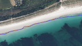
Coastline mapped at intermediate water level based on the water level in the image used for mapping - image: BD Ortho
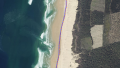
Coastline mapped correctly at the upper limit of the tidal cycle - image: BD Ortho
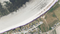
Coastline mapped above the high tide level at the upper end of the beach - image: BD Ortho


Completeness
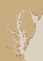
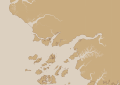
Coastline mapping in OpenStreetMap generally has an level of completeness. Due to the technical requirement of there being no gaps allowed in the coastline mapping, incompleteness practically manifests either in missing islands or the lack of details in coastline mapping. The former can be found in particular in regions with many small islands (Åland Islands, Patagonia, West Greenland coast), the latter in particular in polar regions.
Regions with relatively accurate, detailed and up-to-date coastline mapping are
- Europe
- Japan
- The Philippines
- southern North America
Areas where mapping is widely relatively non-detailed, inaccurate or out-of-date are
- Northern Canada
- Antarctica
- Greenland (except Northeast)
- Northern and Western Australia
- The Caspian Sea
- Red Sea east coast
History of use
Coastline mapping in OpenStreetMap started very early and before the currently used OSMCoastline process was developed. Originally, natural=coastline was not only used for seashore mapping bus also for large inland waterbodies. This use was step by step reduced over the years and is generally not practiced any more - with the mentioned exception of the Caspian Sea.
For significant parts of the world, PGS data was imported early on and parts of this data still remain in some more remote parts of the planet - with the mentioned bias of overestimating the water extent in some areas.
Analysis maps
 |
| Minimum age of nodes |
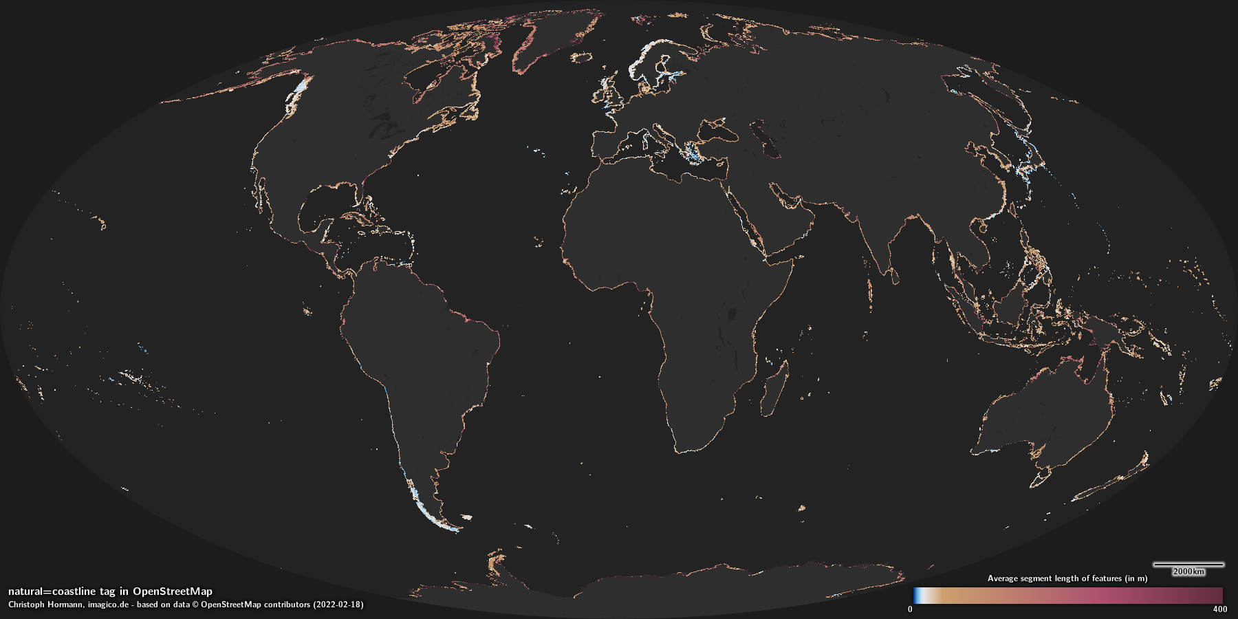 |
| Average segment length |
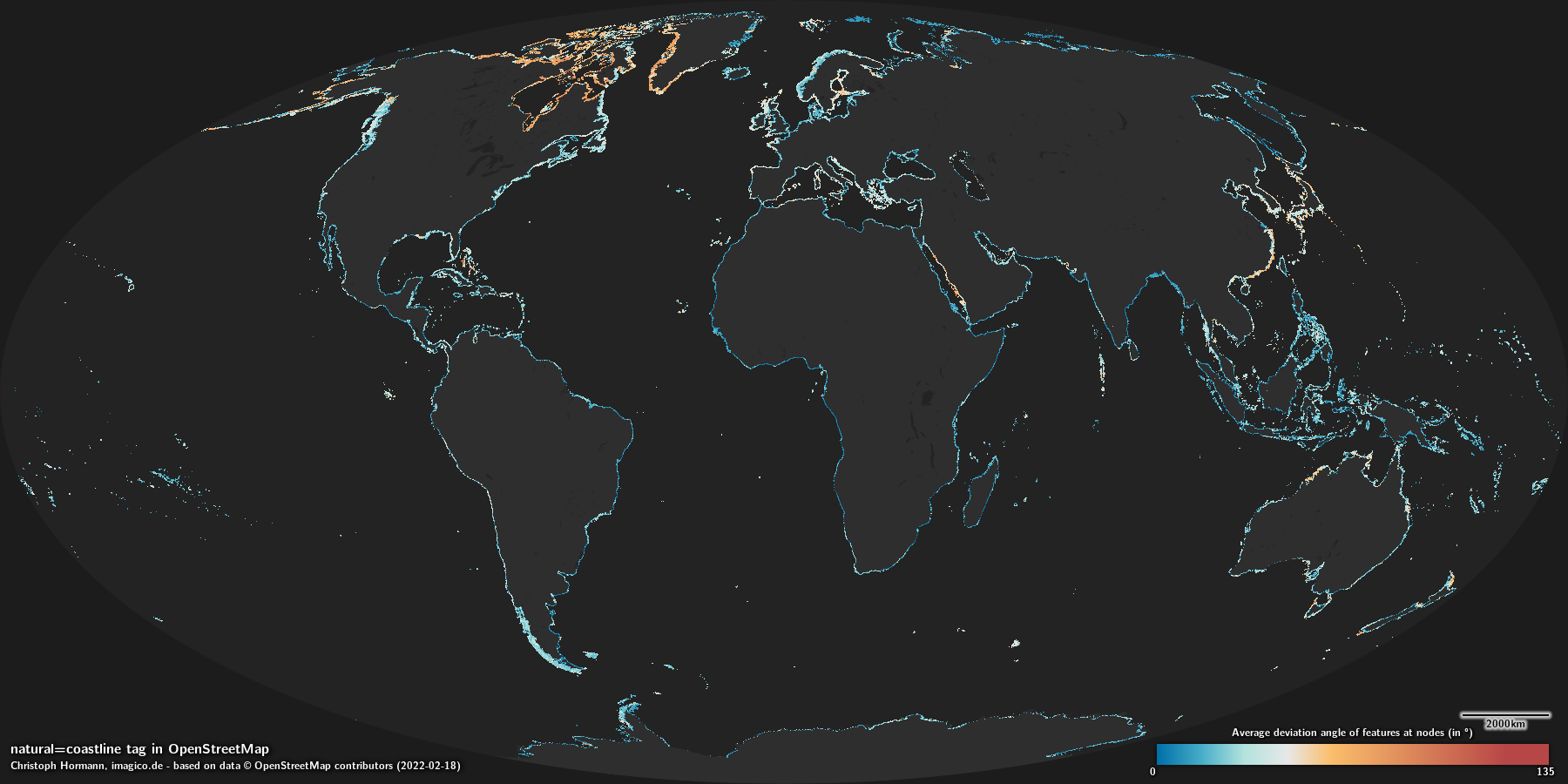 |
| Average deviation angle |
Rendering
Almost all OpenStreetMap based maps render the ocean as defined by the coastline with a plain color or pattern fill, most in the same color/pattern as inland water areas.
 |
| z0 |
 |
| z1 |
 |
| z2 |
 |
| z3 |
 |
| z4 |
 |
| z5 |
 |
| z6 |
 |
| z7 |
 |
| z8 |
 |
| z9 |
 |
| z10 |
 |
| z11 |
 |
| z12 |
 |
| z13 |
 |
| z14 |
 |
| z15 |
 |
| z16 |
 |
| z17 |
 |
| z18 |
 |
| z19 |
 |
| z0 |
 |
| z1 |
 |
| z2 |
 |
| z3 |
 |
| z4 |
 |
| z5 |
 |
| z6 |
 |
| z7 |
 |
| z8 |
 |
| z9 |
 |
| z10 |
 |
| z11 |
 |
| z12 |
 |
| z13 |
 |
| z14 |
 |
| z15 |
 |
| z16 |
 |
| z17 |
 |
| z18 |
 |
| z19 |
- Oceanography tags
- Hydrography tags
- Physical Geography tags
- Primary Tags
- Discrete Classification Tags
- Divisible geometry features
- Tags where way direction is significant
- Tags with good consistency
- Tags with excellent verifiability
- Tags with good geometric accuracy
- Tags with excellent completeness
- Tags
- Tags with maps
- Tags with rendering samples