Views of the Earth

artificial images of our real planet
Central Crete location map

Central Crete

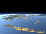
The island of Crete is a large island in the Mediterranean Sea between the Greek mainland and Libya. It has been home to the Minoan civilization as early as 4500 years ago. This view covers the central part of the island with the isthmus of Ierapetra on the foreground right, the Dikti Mountains in the center, the Mesara Plain on the left and the Psiloritis and Lefka Ori mountain ranges in the background. In the far background the Greek mainland and some smaller islands can be seen.

View: Central Crete
Location: Lon 26.144°
Lat 34.772°
Altitude: 19 km
Direction: 303°
Camera Angle: 54°
User Rating: 2.2
Location Map:    Visible Topography
Central Crete location map
Central Crete

Related Views:

Greece 1
Greece 2
Western Crete

Visitor comments:

no comments yet.

Leave a comment
You have to enable Javascript to be able to write comments.
human verification Please enter the code you can see in the image on the left to verify you are a human and not a spamming script.
* * Required field
Information about you
*
will not be made public
will be displayed with your posting
Your comment (no HTML)

*

If you want to send a private message to the author of this website you can do so via Email.

The comments will be reviewed before they are added to the site. So you might need to wait some time until your entry turns up.

Please note this comment function is intended for commenting on the text and images, not for discussing political or religious views. Comments with no relation to the content of this site will not be approved.

By submitting your comment you agree to the privacy policy and agree to the information you provide (except for the email address) to be published on this website.

  
Design and Content Copyright 2023 by Christoph Hormann
last updated Sun, 16 Jul 2023 20:38