Welcome to my web site, most of the images you can see here are calculated with the computer. You can view those as well as some of my photographs in the sections listed below. Furthermore you can find information on the production techniques used.


Imagico.de services and products
(
 )
)
From the catalog:
The Bering Strait
View of the Bering Strait between Alaska and Russia from the southeast with Alaska in the foreground, the Aleutian Islands and Kamchatka on the left... [more]

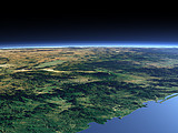
Views of the Earth
(
)
artificial images of our real planet
Featured image:
Colima Volcano
This View shows the green Pacific coast of Mexico with the Colima Volcano (4330m) and Lake Chapala and in the background the dryer high plateau of... [more]

Imagico.de blog
(
)


Raytracing - synthetical images
(
)
Images and background information on image production using raytracing:
-
Gallery
(
)
-
Tutorials and tables
(
)
-
Tools and include files
(
)