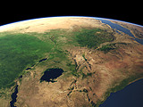
Madagascar
The island of Madagascar is the fourth largest island on Earth and due to its long time isolation from the African continent in the background home to many unique endemic plants and animals. Due to the trade winds the eastern coast is particularly green and humid while the central and western parts are drier.
| View: | Madagascar |
| Location: | Lon 55.086° Lat -25.938° |
| Altitude: | 729 km |
| Direction: | 311° |
| Camera Angle: | 52° |
| User Rating: | 2.4 |
Location Map: Visible Topography

Home •
Impressum •
Terms •
Sitemap •
Browse:
list
/
map /
gallery •

imagico.de • blog.imagico.de • services.imagico.de • maps.imagico.de • earth.imagico.de • photolog.imagico.de
imagico.de • blog.imagico.de • services.imagico.de • maps.imagico.de • earth.imagico.de • photolog.imagico.de


Visitor comments:
no comments yet.
By submitting your comment you agree to the privacy policy and agree to the information you provide (except for the email address) to be published on this website.