Kanyakumari/Cape Comorin
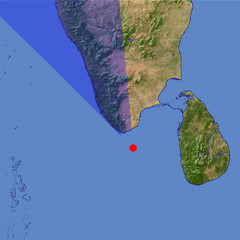
The southmost point of the Indian Peninsula marks the end of the Western Ghats mountain range that continues north parallel to the west coast on the left of this view. The historic town Calicut that has been a trade center for spices and other products of India and East Asia since medieval times is located in the far background.
| Ansicht: | Kanyakumari/Cape Comorin |
| Position: | Lon 77.933° Lat 7.415° |
| Höhe: | 39 km |
| Richtung: | 335° |
| Kamerawinkel: | 39° |
| Bewertung: | 2.5 |
Umgebungskarte: Optisch Topographie

Start •
Impressum •
Nutzungsbedingungen •
Sitemap •
Bilder:
Liste
/
Karte /
Galerie •

imagico.de • blog.imagico.de • services.imagico.de • maps.imagico.de • earth.imagico.de • photolog.imagico.de
imagico.de • blog.imagico.de • services.imagico.de • maps.imagico.de • earth.imagico.de • photolog.imagico.de


Kommentare:
Durch das Abschicken Ihres Kommentars stimmen Sie der Datenschutzrichtlinie zu und erlauben, dass die eingegebenen Informationen (mit Ausnahme der eMail-Adresse) in diesem Blog veröffentlicht werden.