Imagico.de
Geovisualizations
by Christoph Hormann
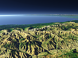
Spring in San Fancisco
View information

The San Fancisco Bay area in April 2016. Image is based on Copernicus Sentinel data from 2016, attribution required.
| view data | |
|---|---|
| Location: | 122.4° W, 37.75° N |
| Altitude: | 786 km |
| View Direction: | 0° |
| Camera Angle: | 0° |
| Available size: | up to 14000×13000 pixel |
License inquiry
Blog news:
Trends for the future of map design in OpenStreetMap (20 Apr 2024)
The current state of map design in OpenStreetMap (18 Apr 2024)
Digital map design history (16 Apr 2024)
Addresses and Entrances (11 Apr 2024)
Todays featured image:
The Kaçkar Mountains
View of the Kaçkar Mountains which is the highest part of the Pontic Mountains in northern Turkey with the Kaçkar Dağı (3937m). The Black Sea is... [more]
The most important sections:
Design and Content Copyright 2024 by Christoph Hormann
last updated Sat, 30 Mar 2024 23:52