The Scandinavian Peninsula
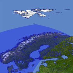
The Scandinavian Peninsula in northern europe has been covered by a thick ice sheet during the last Ice Age and its surface is primarily formed by the glaciers. The western coast is structured by many fjords.and islands while the eastern coast slowly inclines towards the Baltic Sea. In the close foreground the North Cape and the northmost point of the European mainland can be seen.
| Ansicht: | The Scandinavian Peninsula |
| Position: | Lon 47.818° Lat 75.342° |
| Höhe: | 729 km |
| Richtung: | 215° |
| Kamerawinkel: | 40° |
| Bewertung: | 2.5 |
Umgebungskarte: Optisch Topographie

Start •
Impressum •
Nutzungsbedingungen •
Sitemap •
Bilder:
Liste
/
Karte /
Galerie •

imagico.de • blog.imagico.de • services.imagico.de • maps.imagico.de • earth.imagico.de • photolog.imagico.de
imagico.de • blog.imagico.de • services.imagico.de • maps.imagico.de • earth.imagico.de • photolog.imagico.de


Kommentare:
noch keine Kommentare.
Durch das Abschicken Ihres Kommentars stimmen Sie der Datenschutzrichtlinie zu und erlauben, dass die eingegebenen Informationen (mit Ausnahme der eMail-Adresse) in diesem Blog veröffentlicht werden.