Imagico.de
Catalog search
Search parameters
Keywords: none specified
Style: high altitude views
Minimum available size: arbitrary
Longitude: -180° to 180°, Latitude: -90° to 90°
Purpose: for licensing
Results (?)
Europe from northwest

View of the central part of Europe from northwest reaching from southern Scandinavia to southern France with Great Britain and Ireland prominently in the foreground. Uses waterbody data copyright OpenStreetMap contributors.
| view data | |
|---|---|
| Location: | 29.007° W, 58.401° N |
| Altitude: | 1321.86 km |
| View Direction: | 108° |
| Camera Angle: | 45° |
| Available size: | up to 9600×5400 pixel |
Great Britain and Ireland from southwest

View of View of Great Britain and Ireland from southwest. Uses waterbody data copyright OpenStreetMap contributors.
| view data | |
|---|---|
| Location: | 10.781° W, 44.021° N |
| Altitude: | 1021.86 km |
| View Direction: | 31° |
| Camera Angle: | 35° |
| Available size: | up to 6400×6400 pixel |
Central Europe from southeast

View of Central Europe from the southeast with the Alps in the middle, Italy in the foreground and France and Germany in the background. Uses waterbody data copyright OpenStreetMap contributors.
| view data | |
|---|---|
| Location: | 19.627° E, 33.353° N |
| Altitude: | 1021.86 km |
| View Direction: | 326° |
| Camera Angle: | 45° |
| Available size: | up to 9600×5400 pixel |
The western Mediterranean Sea

View of the western Mediterranean Sea from southwest with the Iberian peninsula on the left and North Africa on the foreground right. Uses waterbody data copyright OpenStreetMap contributors.
| view data | |
|---|---|
| Location: | 8.83° W, 27.299° N |
| Altitude: | 1021.86 km |
| View Direction: | 32° |
| Camera Angle: | 48° |
| Available size: | up to 9600×5400 pixel |
The Iberian peninsula

View of the Iberian peninsula from southwest with the Strait of Gibraltar in the foreground and France in the background. Uses waterbody data copyright OpenStreetMap contributors.
| view data | |
|---|---|
| Location: | 8.207° W, 34.028° N |
| Altitude: | 1021.86 km |
| View Direction: | 32.5° |
| Camera Angle: | 45° |
| Available size: | up to 7200×9600 pixel |
The Balkan Peninsula

View of the Balkan Peninsula from southeast with Greece, western Turkey and the Aegean Sea in the foreground. Uses waterbody data copyright OpenStreetMap contributors.
| view data | |
|---|---|
| Location: | 28.411° E, 32.889° N |
| Altitude: | 1021.86 km |
| View Direction: | 327° |
| Camera Angle: | 45° |
| Available size: | up to 7200×9600 pixel |
Eastern Europe from south

View of Eastern Europe from the south. Uses waterbody data copyright OpenStreetMap contributors.
| view data | |
|---|---|
| Location: | 14.945° E, 21.358° N |
| Altitude: | 2821.86 km |
| View Direction: | 359.5° |
| Camera Angle: | 36° |
| Available size: | up to 9600×5400 pixel |
Western Europe from south

View of Western Europe from the south. Uses waterbody data copyright OpenStreetMap contributors.
| view data | |
|---|---|
| Location: | 6.163° E, 22.298° N |
| Altitude: | 2821.86 km |
| View Direction: | 0.5° |
| Camera Angle: | 35° |
| Available size: | up to 9600×5400 pixel |
Western Europe from southeast

View of Western Europe from the southeast from the Iberian Penisula to Italy and Western Scandinavia. Uses waterbody data copyright OpenStreetMap contributors.
| view data | |
|---|---|
| Location: | 16.138° E, 25.347° N |
| Altitude: | 2821.86 km |
| View Direction: | 328.5° |
| Camera Angle: | 35° |
| Available size: | up to 9600×5400 pixel |
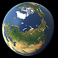
The North Pole

View of the Arctic Ocean around the North Pole with Greenland on the left, Svalbard in the foreground and the Russian Arctic with Franz Josef Land, Novaya Zemlya, Severnaya Zemlya and the New Siberian Islands on the right.
| view data | |
|---|---|
| Location: | 20° E, 64.358° N |
| Altitude: | 2821.86 km |
| View Direction: | 0° |
| Camera Angle: | 42° |
| Available size: | up to 4800×2700 pixel |
The Bering Strait

View of the Bering Strait between Alaska and Russia from the southeast with Alaska in the foreground, the Aleutian Islands and Kamchatka on the left and the ice covered Arctic Ocean on the right with Wrangel Island and the New Siberian Islands visible.
| view data | |
|---|---|
| Location: | 142.532° W, 49.306° N |
| Altitude: | 2821.86 km |
| View Direction: | 310° |
| Camera Angle: | 42° |
| Available size: | up to 4800×2700 pixel |
Northern Canada and Greenland

View of the northmost part of Canada and Greenland with the ice covered Arctic Ocean in the background. On the foreground right the northern part of Baffin Bay and on the right the North Atlantic Ocean.
| view data | |
|---|---|
| Location: | 79.001° W, 61.64° N |
| Altitude: | 2821.86 km |
| View Direction: | 16° |
| Camera Angle: | 42° |
| Available size: | up to 4800×2700 pixel |
Greenland from north

View of Greenland from the north with the ice covered Arctic Ocean in the foreground, Ellesmere Island and Baffin Island on the right and Svalbard and Iceland on the left.
| view data | |
|---|---|
| Location: | 121.558° E, 80.858° N |
| Altitude: | 2821.86 km |
| View Direction: | 193° |
| Camera Angle: | 42° |
| Available size: | up to 4800×2700 pixel |
The Middle East and the Mediterranean

View of the Middle East and the Mediterranean region from Spain in the west up to Iran in the East
| view data | |
|---|---|
| Location: | 29° E, 17.358° N |
| Altitude: | 5629 km |
| View Direction: | 0° |
| Camera Angle: | 40° |
| Available size: | up to 8000×6000 pixel |
The eastern Mediterranean

View of the eastern Mediterranean Sea from Greece to Jordan and from Egypt to Turkey
| view data | |
|---|---|
| Location: | 31.772° E, 21.987° N |
| Altitude: | 1029 km |
| View Direction: | 355° |
| Camera Angle: | 42° |
| Available size: | up to 8000×6000 pixel |
New Zealand as a whole

View of the whole of New Zealand
| view data | |
|---|---|
| Location: | 178.679° E, 55.337° S |
| Altitude: | 729 km |
| View Direction: | 342° |
| Camera Angle: | 42° |
| Available size: | up to 8000×6000 pixel |
The Himalaya and Tibet

View of the whole Himalaya range and the Tibet plateau
| view data | |
|---|---|
| Location: | 97.237° E, 14.065° N |
| Altitude: | 2029 km |
| View Direction: | 336° |
| Camera Angle: | 36° |
| Available size: | up to 8680×5560 pixel |
The Bay of Bengal

The Bay of Bengal with India and Sri Lanka on the left and the Andaman and Nicobar islands and Sumatra on the right
| view data | |
|---|---|
| Location: | 82.056° E, 8.568° S |
| Altitude: | 3629 km |
| View Direction: | 14° |
| Camera Angle: | 41° |
| Available size: | up to 9567×7175 pixel |
East Africa and the Great Rift

View of Eastern Africa with the Great Rift, the upper Nile river and the eastern part of the Congo Basin
| view data | |
|---|---|
| Location: | 38.639° E, 17.56° S |
| Altitude: | 2029 km |
| View Direction: | 349° |
| Camera Angle: | 35° |
| Available size: | up to 8000×6000 pixel |
Southern Europe and northern Africa

Showing the western Mediterranean Sea and southern Europe as well as northern Africa
| view data | |
|---|---|
| Location: | 5.303° E, 16.823° N |
| Altitude: | 2829 km |
| View Direction: | 1.5° |
| Camera Angle: | 35° |
| Available size: | up to 3200×1600 pixel |
Europe from south

View of central Europe from South with Spain, the Balearic Islands, Sardinia, Corsica and Italy in the foreground.
| view data | |
|---|---|
| Location: | 6.563° E, 22.298° N |
| Altitude: | 2829 km |
| View Direction: | 0.5° |
| Camera Angle: | 34° |
| Available size: | up to 6400×3840 pixel |
Europe from south 2

Another view of Europe from South (available with transparent sky)
| view data | |
|---|---|
| Location: | 6.863° E, 22.319° N |
| Altitude: | 2829 km |
| View Direction: | 0.5° |
| Camera Angle: | 34° |
| Available size: | up to 4000×2500 pixel |
Israel and the Sinai peninsula

View of Israel and the Sinai peninsula from northeast with the Mediterranean on the right and the Red Sea on the left
| view data | |
|---|---|
| Location: | 39.195° E, 36.774° N |
| Altitude: | 329 km |
| View Direction: | 216° |
| Camera Angle: | 36° |
| Available size: | up to 5120×3840 pixel |
Southern Europe

Small view of southern Europe and the Mediterranean Sea
| view data | |
|---|---|
| Location: | 26.77° E, 3.426° N |
| Altitude: | 5629 km |
| View Direction: | 344° |
| Camera Angle: | 32° |
| Available size: | up to 2200×520 pixel |
Western Europe

Portrait view of Western Europe with France and Great Britain
| view data | |
|---|---|
| Location: | 0.482° W, 41.971° N |
| Altitude: | 1329 km |
| View Direction: | 357.8° |
| Camera Angle: | 43° |
| Available size: | up to 3000×4242 pixel |
Western Canada

Narrow view of the Coast of western Canada with transparent background
| view data | |
|---|---|
| Location: | 119.349° W, 18.962° N |
| Altitude: | 2829 km |
| View Direction: | 354° |
| Camera Angle: | 30° |
| Available size: | up to 1200×270 pixel |
Blog news:
Todays featured image: