Imagico.de
Geovisualizations
by Christoph Hormann
Northern Canada and Greenland
View information

View of the northmost part of Canada and Greenland with the ice covered Arctic Ocean in the background. On the foreground right the northern part of Baffin Bay and on the right the North Atlantic Ocean.
| view data | |
|---|---|
| Location: | 79.001° W, 61.64° N |
| Altitude: | 2821.86 km |
| View Direction: | 16° |
| Camera Angle: | 42° |
| Available size: | up to 4800×2700 pixel |
License inquiry
Blog news:
Drawing the line #4 – Plumbing (28 Nov 2024)
More map symbols (01 Nov 2024)
Is the OSMF not overly fond of OpenStreetMap? (25 Oct 2024)
Point barriers (23 Oct 2024)
Todays featured image:
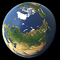
Whole earth view focusing on Siberia and the North Pole
Whole earth view focusing on Siberia and the North Pole with summer coloring of the earth surface [more]
The most important sections:
Design and Content Copyright 2025 by Christoph Hormann
last updated Mon, 03 Feb 2025 23:38