Imagico.de
Geovisualizations
by Christoph Hormann
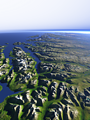
Eastern Spitzbergen
View information

View of the eastern coast of the island Spitzbergen in Svalbard with the Storfjorden on the bottom right and the strongly glaciated Olav-V-Land and the Hinlopenstretet behind separating Spitzbergen from Nordaustlandet on the far right. Uses data from the Norwegian Polar Institute (CC-By 4.0).
| view data | |
|---|---|
| Location: | 19.881° E, 76.805° N |
| Altitude: | 51.863 km |
| View Direction: | 345° |
| Camera Angle: | 46° |
| Available size: | up to 8000×6000 pixel |
License inquiry
Blog news:
Drawing the line #4 – Plumbing (28 Nov 2024)
More map symbols (01 Nov 2024)
Is the OSMF not overly fond of OpenStreetMap? (25 Oct 2024)
Point barriers (23 Oct 2024)
Todays featured image:
The Norwegian coast east of Tromsø
View of the rugged coast of northern Norway east of the Town of Tromsø with the Lyngen Alps and the Lyngen fjord on the center left. Uses data... [more]
The most important sections:
Design and Content Copyright 2024 by Christoph Hormann
last updated Sat, 30 Mar 2024 23:52