Imagico.de
Geovisualizations
by Christoph Hormann


Catalog search
Search parameters
Keywords: iceland
Style: island
Minimum available size: arbitrary
Longitude: -34.2° to -0.6°, Latitude: 49.0° to 76.7°
Purpose: for licensing
Results (?)
Iceland from South

View of Iceland from south with the Eastern Greenland coast and Jan Mayen in the background.
| view data | |
|---|---|
| Location: | 23.463° W, 61.209° N |
| Altitude: | 209 km |
| View Direction: | 25° |
| Camera Angle: | 55° |
| Available size: | up to 9600×5482 pixel |
Iceland from straight above

View of Iceland from straight above
| view data | |
|---|---|
| Location: | 18.5° W, 64.999° N |
| Altitude: | 2629 km |
| View Direction: | 0° |
| Camera Angle: | 15° |
| Available size: | up to 3840×2160 pixel |
View of whole Iceland

View of whole Iceland with the Coast of eastern Greenland in the background
| view data | |
|---|---|
| Location: | 14.586° W, 61.218° N |
| Altitude: | 209 km |
| View Direction: | 335° |
| Camera Angle: | 56° |
| Available size: | up to 3840×2160 pixel |
Central Iceland and the Vatnajökull
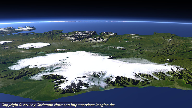
This view of the central part of Iceland from South shows the Vatnajökull glacier in the foreground.
| view data | |
|---|---|
| Location: | 15.224° W, 62.96° N |
| Altitude: | 59 km |
| View Direction: | 335° |
| Camera Angle: | 46° |
| Available size: | up to 3840×2160 pixel |
Blog news:
Trends for the future of map design in OpenStreetMap (20 Apr 2024)
The current state of map design in OpenStreetMap (18 Apr 2024)
Digital map design history (16 Apr 2024)
Addresses and Entrances (11 Apr 2024)
Todays featured image:
Western Himalaya with Lake Manasarovar and Mount Kailash
View of the Western Himalaya with Lake Manasarovar on the Tibetean Plateau and Mount Kailash on the far right [more]
The most important sections:

Design and Content Copyright 2024 by Christoph Hormann
last updated Sat, 30 Mar 2024 23:52