Imagico.de
Geovisualizations
by Christoph Hormann
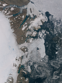
Northeast Greenland in August
View information

Landsat mosaic of the coast of Northeast Greenland in August 2014 showing the eastern edge of the Greenland Ice sheet with the Nioghalvfjerdsbrae and the Zachariae Isstrom, Kronprins Christian Land and the Independence Fjord as well as the coastal and sea ice situation at the height of summer.
| view data | |
|---|---|
| Location: | 21° W, 79° N |
| Altitude: | 700 km |
| View Direction: | 0° |
| Camera Angle: | 0° |
| Available size: | up to 32600×42800 pixel |
License inquiry
Blog news:
More map symbols (01 Nov 2024)
Is the OSMF not overly fond of OpenStreetMap? (25 Oct 2024)
Point barriers (23 Oct 2024)
A few additional comments on the new OSM-Carto release (17 Oct 2024)
Todays featured image:
Northeast Greenland in August
Landsat mosaic of the coast of Northeast Greenland in August 2014 showing the eastern edge of the Greenland Ice sheet with the Nioghalvfjerdsbrae and... [more]
The most important sections:
Design and Content Copyright 2024 by Christoph Hormann
last updated Sat, 30 Mar 2024 23:52