Imagico.de
Geovisualizations
by Christoph Hormann
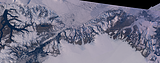
Norwegian Coast
View information

View of the northern part of the coast of Norway with the counties of Nordland and Troms and the town of Bodø near the center. In the foreground you can see the bright ice of the Svartisen glacier and on the left behind the Vestfjorden separates the Lofoten from the mainland. Norway only forms a narrow area near the coast and the coastal mountains here, most of the lakes on the right side are already in Sweden. Uses data copyright OpenStreetMap contributors and elevation data from Kartverket (CC-By 4.0).
| view data | |
|---|---|
| Location: | 13.707° E, 66.042° N |
| Altitude: | 111.863 km |
| View Direction: | 34.5° |
| Camera Angle: | 58° |
| Available size: | up to 7200×9600 pixel |
License inquiry
Blog news:
Drawing the line #4 – Plumbing (28 Nov 2024)
More map symbols (01 Nov 2024)
Is the OSMF not overly fond of OpenStreetMap? (25 Oct 2024)
Point barriers (23 Oct 2024)
Todays featured image:
Northern Greenland Autumn 2018
Landsat mosaic of Northern Greenland and Northern Ellesmere Island in late August/early September 2018. This includes the nearly cloud free... [more]
The most important sections:
Design and Content Copyright 2024 by Christoph Hormann
last updated Sat, 30 Mar 2024 23:52