Imagico.de
Geovisualizations
by Christoph Hormann
Spring in San Fancisco
View information

The San Fancisco Bay area in April 2016. Image is based on Copernicus Sentinel data from 2016, attribution required.
| view data | |
|---|---|
| Location: | 122.4° W, 37.75° N |
| Altitude: | 786 km |
| View Direction: | 0° |
| Camera Angle: | 0° |
| Available size: | up to 14000×13000 pixel |
License inquiry
Blog news:
Drawing the line #4 – Plumbing (28 Nov 2024)
More map symbols (01 Nov 2024)
Is the OSMF not overly fond of OpenStreetMap? (25 Oct 2024)
Point barriers (23 Oct 2024)
Todays featured image:
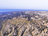
The Deosai plateau
View of the Deosai plateau from the east with the upper Indus valley to the right and the Nanga Parbat on the background left. [more]
The most important sections:
Design and Content Copyright 2024 by Christoph Hormann
last updated Sat, 30 Mar 2024 23:52