Parking of vehicles that are not in use is one of the most peculiar aspect of our present day societies dominated by individually owned automobile transport. Typical numbers quoted for the time cars – on average – spend in parking are 23 hours per day or 95 percent of the time. Studies on surface area use show something around 5 percent of urban areas are used for parking in the US (detailed stats for the US per county can be found here).
At the same time, awareness of this significance of automobile parking is not that high in our society. And this is also reflected in cartographic practice. Roads, that is structures for moving automobiles (where the average car spends around five percent of its time), are typically very prominent in maps while parking infrastructure is frequently marginalized.
Explicit mapping of parking infrastructure in OpenStreetMap
OpenStreetMap is no exception here – though relative to other maps and map databases parking structures have a higher weight in OSM. They are still under-represented relative to their significance in urban geography, but they are less marginalized than in traditional maps.
The most important tag to explicitly represent parking infrastructure is amenity=parking. This tag is essentially used for any place where two-tracked automobiles are parked on a regular basis. This ranges from a few small parking spaces in front of a shop over a strip along the side of a road where cars are routinely parked to a big parking lot with hundreds of spaces. amenity=parking is used more than five million times in OpenStreetMap, that is within the top 30 most commonly mapped feature types – within the top 15 if you aggregate the different variants of roads and buildings into a single feature type.
As said amenity=parking is for two-tracked automobile parkings, for bicycles and motorcycles there are separate primary tags (amenity=bicycle_parking and amenity=motorcycle_parking). And while amenity=parking is predominantly used on polygons, the latter two are predominantly mapped with nodes.
Other primary tags used for infrastructure for parking vehicles are:
amenity=parking_spaceis used for mapping the specific area where cars are parked within anamenity=parkingamenity=parking_entranceis used for mapping an entrance to an underground or multi storey parking facilitylanduse=garagesis used for areas with privately operated buildings in which cars are parked (garages)building=garageis used to map individual privately operated buildings in which a single car is parkedbuilding=garagesis used to map buildings with separately accessible individual parking spaces for carsbuilding=carportis used to map weather protection roofs above individual parking spaces
Here the use numbers of these tags in the OSM database:
| tag | total | polygons | nodes |
|---|---|---|---|
amenity=parking |
5.2M | 4.8M | 393k |
amenity=bicycle_parking |
618k | 525k | 93k |
amenity=motorcycle_parking |
34k | 22k | 12k |
amenity=parking_space |
2.3M | 2.2M | 116k |
amenity=parking_entrance |
186k | 631 | 185k |
landuse=garages |
82k | 82k | 36 |
building=garage |
6.6M | 6.6M | 2k |
building=garages |
875k | 874k | 492 |
building=carport |
196k | 196k | 48 |
Implicit mapping of parking in OpenStreetMap
In addition to the tags discussed so far, OpenStreetMap also quite extensively maps parking infrastructure implicitly on roads. This is most commonly done through
| tag | use |
|---|---|
parking:both=lane |
27k |
parking:both=street_side |
6.4k |
parking:left=lane |
13k |
parking:left=street_side |
7k |
parking:right=lane |
18k |
parking:right=street_side |
9k |
As you can see, this method is much less commonly used than the explicit mapping methods overall. The numbers are, however, not insignificant, and for parking lanes on the road this method is at least similarly widespread compared to explicit mapping.
Rendering in OpenStreetMap Carto
OSM-Carto, like nearly all other map styles, so far only renders explicit forms of mapping parkings. Here is how this looks like at the highest zoom levels:
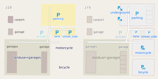
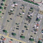
Parking infrastructure rendering in OSM-Carto and in the current version (right) as well as version 1 (left)
In the early days of OpenStreetMap, amenity=parking was shown significantly more prominently than it is today. While the yellow used was similar to both tertiary roads and natural=beach, it typically allowed for a fairly good identification of areas covered with parking lots in an urban environment. The current generic gray color, however, is much less identifiable and identical to the color used for living streets. Most other OSM map styles use a similarly muted (or even weaker) coloring for parking polygons – though they vary significantly in the weight of point symbols used.
In the AC-Style i have struggled for some time with selecting a suitable color for parkings during my color reorganization work. Ultimately i chose a bright, low saturation orange with a stronger orange outline. This – in combination with the violet used for transportation symbols – produces a very distinct look for parking features while also harmonically integrating with the color scheme for roads.

Parking infrastructure rendering in the AC-Style until now
As you can also see, i had not yet ported the more recent additions of rendering of amenity=parking_space and amenity=parking_entrance in OSM-Carto to my style.
Secondary Tags
The really interesting thing about mapping of parking infrastructure in OpenStreetMap is, however, the wealth of secondary tags that are used for further characterizing parking features – both on the parking infrastructure features listed above and on roads for implicit mapping of street side parking.
Mappers in OSM have not only developed detailed tagging schemes for these (in particular here) – some of these secondary tags are also applied in remarkable numbers despite being shown on hardly any maps. In that regard parking infrastructure mapping competes with road characteristics (where secondary tags are, however, also used for routing purposes) and natural=tree (where i introduced a detailed rendering system for secondary tags some time ago).
The only secondary tags for parking infratructure that are so far interpreted by OSM-Carto are access tags indicating restricted access (which have been shown with a different symbol and label color already in version 1) and the parking=* tags – which are used to display a smaller symbol for parking=lane and parking=street_side and for differentiating amenity=parking_entrance in underground and multi-storey parkings.
In the next post i am therefore going to introduce some new rendering concepts for visualizing other secondary attributes on parking infrastructure that are commonly mapped in OpenStreetMap and well as concepts for visualizing implicitly mapped parking infrastructure.
Source of header image: Swiss Bundesamt für Landestopografie swisstopo.
Pingback: weeklyOSM 702 – weekly – semanario – hebdo – 週刊 – týdeník – Wochennotiz – 주간 – tygodnik