I have written about and demonstrated the generalization of data for natural features in a map like coastlines, waterbodies and glaciers. Artificial elements have so far not been included there. The most obvious starting point are the human settlements. I suppose many do not know that these are the only place where the well known standard OpenStreetMap map style makes use of external data not acquired and maintained by the OSM community (whith the exception of zoom levels 1-3 where other external data is used as well). I here explain the reasons for this use of external data and a possible approach to replace this with data derived from the information in the OSM database in more detail.
Data of human settlements is the core of mapping in OpenStreetMap which means the task at hand here requires massive data reduction. Only looking at the buildings there are more than 110 million of them in the OSM database with about 500 million nodes. Many of these are located in Central Europe so producing the sample data set you can see below is a task of reducing several gigabytes of data to just a few megabytes.

This has to be done in an efficient way and at the same time needs to cope with varying mapping styles and different levels of completeness in the various regions. Read the full text on the subject of generalizing OSM settlement data to find out about the details and to download the sample data set to try this out in your maps. The tools employed to perform this processing will be available as open source like the other generalization tools.
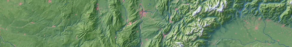
Below you can see an example how such OSM derived generalized settlement data can be used in map rendering.
