
There has been quite a bit of fuzz in the OSM community recently (like here – warning: link goes to patronizing and broken web interface) because one of the image layers with semi-global coverage that had so far been widely used by mappers as a source for remote (armchair-) mapping has been turned off.
Calls for the authorities (in other words: the OSMF) to fix this were quick and the OSMF board seems to try persuading the image provider to restore the status quo ante. Sadly, however, the event seems to have not initiated any larger scale reflection within the OSM community on its dependency on proprietary data providers, which has increased significantly over the past years.
In wealthy parts of the world with active mapper communities local mappers have over the years invested significant work into collecting suitable local image sources (i.e. aerial images) and obtained permission to use those for mapping in OpenStreetMap from their providers. This not only applies to Europe and North America but also other parts of the world like Japan and parts of South America for example. This is an impressive achievement and highly useful for the practical work of mappers. And because all these image sources are independently produced and provided by different local image providers there is no problematic large scale dependency on a single image source because of that.
But this only applies to a rather limited part of the Earth land surface. For the rest OpenStreetMap currently largely depends on a single satellite image provider (Maxar) and image layers based on Maxar imagery provided by a small number of US Corporations (Microsoft/Bing, Esri, Mapbox and – until recently – Maxar itself). This problem is aggravated by the fact that it is in particular those parts of the world where no local aerial image sources are available where OSM currently lacks significantly in mappers with local knowledge and over-proportionally depends on remote mapping. In addition all of the listed image layers to varying extent have a focus on those parts of the world where other local image sources are available as well and elsewhere often have more patchy and lower quality coverage.
I have pointed out in the past that an important avenue for the OSM community to mitigate this dependency is to focus more on using open data satellite imagery. Even if this cannot fully replace commercial images, open data satellite imagery is currently severely underused in OSM, largely because of the lack of convenient practical availability of high quality images from such sources to mappers.
Of course there are other options the OSM community could try to decrease the current dependency on a single imagery provider:
- invest in recruiting mappers with local knowledge in larger parts of the globe (which would of course require the English speaking influential parts of the OSM community to open up more to true cultural diversity).
- invest in the capabilities of mappers to map in high quality in the absence of high spatial resolution imagery. It is quite remarkable how dependent even mappers with local knowledge mapping using on-the-ground surveying are often on image availability. Doing so would consist both in educating mappers in techniques that do not rely on high spatial resolution imagery and equipment that allows precision mapping independent of imagery.
- diversify the supply of commercial satellite imagery. In the resolution class of Maxar (0.5m GSD or better) there is only a single other provider at the moment (Airbus/CNES) but in the slightly lower resolution range (1m GSD or better) there are quite a few more. I am not aware of any initiative from the OSM community to organize access for mappers to imagery from any of these sources on a larger scale.
- lobbying for opening aerial imagery sources in parts of the world where this exists but is not available for mapping in OSM yet.
- invest in production of open data aerial imagery, in particular recorded by UAV.
- better availability of alternatives to optical imagery for mapping in OSM. There are various parts of the world where no very high resolution optical imagery is available for OSM but other open data sources are – like elevation data in polar regions.
Making open data imagery more accessible for mappers
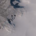
I have tried with my OSM images for mapping over the last years to demonstrate how competent selection and high quality processing of open data satellite imagery can be useful for mapping in OpenStreetMap. I have added some more images of the Antarctic now, substantially reducing the gaps in coverage of ice free parts of the Antarctic.
I have chosen the Antarctic for this in particular because the proprietary higher resolution image layers tend to not have coverage there (or are very patchy). And also because of the high contrasts between ice and ice free areas the tone mapping used by many of the global image layers works poorly in these regions. Unfortunately, mappers in OSM seem to have a tendency to almost universally pick higher spatial resolution images over lower spatial resolution images, even if those are in all other aspects substantially worse (like more than ten years old with seasonal snow cover or poor processing). In other words: Larger scale use of open data satellite imagery in OSM is not only hampered by difficult access to such imagery in high quality, it is also made difficult by the lack of knowledge on the side of many armchair mappers for competent assessment and selection of the best image source for a specific mapping task.
Change in terms of use
Finally i have also changed my terms of use for the image layers for mapping i provide. This is owed to the increasing use of self adjusting algorithms (a.k.a. artificial intelligence) – in general and for satellite image interpretation in particular. The terms i have chosen mean that you can use my images with such algorithms only if the algorithms are fully open source – including the training data and training algorithms. I consider this a prudent choice considering the widespread trends towards neo-feudalism in the world of digital services in general and AI methods in particular. OpenStreetMap can only maintain its paradigm of a self determined cooperation of people with local knowledge sharing this knowledge with one another and the rest of the world (a map by the people for the people) if mappers retain full control over the methods of mapping. And that includes the algorithms used for image analysis.
Pingback: weeklyOSM 685 – weekly – semanario – hebdo – 週刊 – týdeník – Wochennotiz – 주간 – tygodnik
September 12, 2023 at 12:56
Thanks, this is a great highlight of the challenge!
I wanted to personally buy satellite images from the SkyFi service, and create a tile layer for OSM. It could be possible still. I am happy to pay something like $20 to “donate” the image to OSM or to the community who works on the map where the image is. But they said what I cannot do is upload the images to OpenAerialMap, it violates the license. Also, a lot of the SkyFi imagery is not really great in places like central Africa. It could mean something like $300 is needed to task the satellite, which I think is worthy of fetching and giving donations for, if it can be tiled.
September 12, 2023 at 13:53
Thanks for the comment.
In most cases tasking on demand satellite image recording specifically for OSM is practically not necessary or useful. Satellite operators like to advertise this option with priority (because this is the most lucrative part of their business) but practically most mapping needs can be served by archive imagery equally well or better. The typical quality concerns of satellite imagery (like clouds, seasonality, viewing angle) are not going to be addressed well by paying a company to specifically record an image for your use. On the contrary: If you have the background knowledge to select an image for best suitability for mapping purposes in a certain area you will typically be much better in optimizing for those needs when picking among a number of already recorded images than by tasking under conditions not known in advance.
We have had cases in the past where people from the OSM Community discussed paying commercial satellite operators for image licenses. In many cases, however, these discussions took place without first critically assessing if and to what extent there is an actual need that cannot be met by alternatives. Specifically: People discussed licensing commercial imagery without even having seen what open data images are available for the area in question. Independent of what you think in principle of the idea of paying for imagery licenses that is not a good approach and will not lead to well informed decisions.
The other thing you hint at in your comment: You always need to look carefully at the licensing terms. Mapping in OSM is usually not a problematic use case per se but typically licensing terms do not allow public distribution of the imagery. HOT for example has in the past in some cases required mappers to register to gain access to certain imagery that was not available publicly. This is highly problematic for cooperative mapping in OSM where we strongly depend on mappers being able to evaluate each other’s work based on the same sources.
September 22, 2023 at 08:55
In my recent blog post I looked into another approach to generate areal imagery equivalents using LIDAR or 360° cameras. I see a huge potential in this approach for local mapping efforts https://www.openstreetmap.org/user/tordans/diary/401804
For Germany, I am wondering which states still don’t provide their official data for OSM. I think collecting the status quo is a good first step, see https://www.openstreetmap.org/user/tordans/diary/402440
September 22, 2023 at 10:31
The blog post title is a bit confusing since you are talking about ground level imagery, not aerial imagery.
Ground level imagery is helpful and its production easily accessible to most mappers. And SfM techniques are a useful way to interpret ground level imagery to extract additional information. However, practically it is very hard to map geometrically accurately from this kind of data without precision location information (which practically requires RTK-GNSS). Without that mappers will still practically need high resolution satellite/aerial imagery as reference.
Bottom line: I think one of the main keys for geometrically accurate mapping without high resolution satellite/aerial imagery is working on more accessible and more affordable equipment for precision surveying.
Regarding access to aerial imagery recorded by public funding in Germany – Trends and legislation largely work in our favor here. There are still quite a few state mapping agencies which try to keep opposing to opening their data. But it is clearly visible that the attempts in that field are battles of retreat. As mentioned already in the blog post – Central Europe and other wealthy areas are not the main problem here. The economically less significant half of the planet surface is.